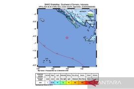
He said the epicenter of the earthquake was located at 4.94 degrees southern latitude and 102.81 degrees eastern longitude at a depth of 17 km.
Chrismanto added that the temblor which did not have potential to trigger a tsunami occurred at south of Sumatra island or some 73 km southwest of South Bengkulu, 76 km southwest of Kaur, 104 km southwest of Pagaralam in South Sumatra, 146 km southeast of Bengkulu, and 462 northwest of Jakarta.
Earlier at 6.18 on Monday evening, another temblor measuring 5.7 on the Richter scale also shook southwest of Banda Aceh in Aceh Province.
The epicenter of the quake was 3.50 degrees north latitude and 92.11 degrees east longitude, 1,937 kilometers northeast of capital city Jakarta at a depth of 74 kilometer, but it did not have the potential to cause a tsunami.
In Sigi district, Central Sulawesi, a magnitude 6.2 earthquake on Saturday evening left four people dead, one seriously injured and 11 lightly wounded, a total of 197 houses heavily damaged, while 41 others lightly.
One of fatality was a nine-year old boy named Ronald from Salua village in Kulawi sub-district.
Ronald was buried on Sunday afternoon at the presence of Sigi deputy district head Livingstone Sango, who is the former head of Kulawi sub-district.
(O001)
Editor: Jafar M Sidik
Copyright © ANTARA 2012


