Head of the Geological Agency, Muhammad Wafid, noted in a statement received here on Saturday that information stating that Tagulandang Island would sink had emerged following a series of eruptions of Mount Ruang on April 17 and April 30, 2024.
The agency emphasized that the information was false and had disturbed the community, especially the residents on Tagulandang Island currently facing the impact of the disaster.
Responding to this, Wafid appealed to the public to remain calm and not believe such irresponsible information.
The agency has prepared information facilities that can be accessed by the public to stay updated on the development of Gunung Ruang activities digitally through the MAGMA Indonesia application and the PVMBG internet page.
They have also deployed officers from the Volcano Observation Post in Tulusan Village, Tagulandang Sub-District, Sitaro, and officers from the Center for Volcanology and Geological Disaster Mitigation (PVMBG) in Bandung, West Java, to disseminate information to the public.
Based on the latest information from the Geological Agency team, it is stated that Mount Ruang's activity is still high based on observations made on Friday (May 3) evening.
During these observations, the Geological Agency team still recorded eruptive earthquakes, shallow volcanic earthquakes, deep volcanic earthquakes, and distant tectonic earthquakes, as well as tremors of relatively small strength.
Meanwhile, visual observations also showed the presence of white-grey crater smoke, with thick and high intensity in the range of 100-300 meters from the top of the crater.
Considering these conditions, Head of the National Disaster Management Agency (BNPB) Suharyanto had earlier stated that the agency is targeting Tagulandang residents living within a seven-kilometer radius from the top of Mount Ruang to be immediately evacuated to refugee camps outside the island.
Based on the latest BNPB data, currently, 5,719 of the approximately 12 thousand residents on Tagulandang Island have not been evacuated, and the BNPB urges that until Sunday (May 5), all residents in the area be moved to refugee camps.
Related news: Mt. Ruang victims' evacuation to be completed within next 72 hours
Related news: Mt Ruang eruption disrupts flights, over 6,000 passengers affected
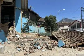
Related news: Mt. Ruang eruption damages 498 houses, public facilities: BNPB
Translator: M. Riezko Bima Elko Prasetyo, Katriana
Editor: Azis Kurmala
Copyright © ANTARA 2024