#tremors
Collection of tremors news, found 375 news.
The Meteorology, Climatology, and Geophysics Agency (BMKG) here on Tuesday reported that a 6.4-magnitude earthquake ...
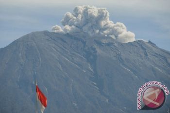
Mount Agung has erupted and is spewing volcanic ash along with smoke columns reaching 2,500 meters, the Energy and ...
The Energy and Mineral Resources Ministry`s Volcanology and Geological Hazard Mitigation Center (PVMBG) reduced Mount ...
Mount Agung in Bali erupted again on Saturday, spewing volcanic ash up to a height of 2,500 meters. An official ...
-- Offering stronger disaster prevention measures with accurate grasp of earthquake observation data -NEC Corporation ...
The Energy and Mineral Resources Ministry`s Volcanology and Geological Hazard Mitigation Center (PVMBG) reported here ...
The Energy and Mineral Resources Ministry`s Volcanology and Geological Hazard Mitigation Center (PVMBG) has reported ...
No casualties have been reported following a 6.9-magnitude earthquake that hit Nyingchi in southwest China`s Tibet ...
A tectonic quake measuring 5.5 on the Richter scale occured in Bali at 5.54 am on Thursday. "The tremor was felt ...
Thousands of Balinese evacuees returned home after living more than a month in evacuation centers on the Island, ...
Mount Lokon in the Indonesian province of North Sulawesi is showing signs of increased activity since Thursday, an ...
The emergency status of Mount Agung in Bali Province has been extended for another 14 days, until Nov 9, to anticipate ...
The relocation of Mt Sinabung refugees in Karo District, North Sumatra, will be completed by the end of 2018, ...
The emergency status for Mount Agung in Bali Province has been extended for another 14 days until Oct 26, as the ...
The National Disaster Mitigation Agency (BNPB) will use three kinds of drones to monitor the development of Mount ...


