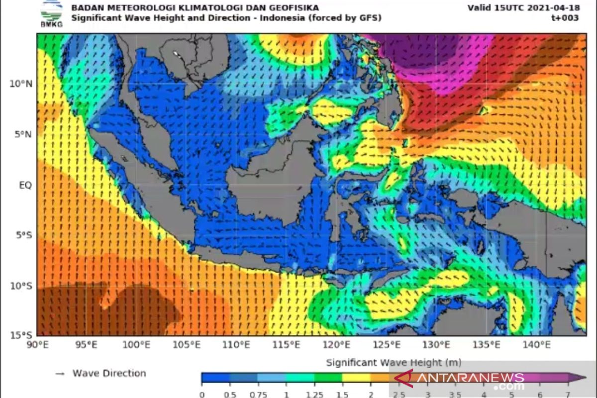
"We urge the public to be aware of the high waves projected to occur in several areas of the Indonesian waters owing to the Surigae tropical cyclone," Head of the BMKG Maritime Meteorology Center Eko Prasetyo stated here on Monday.
In addition, waves, reaching as high as 2.5-4 meters, are also likely to arise in the Sangihe Islands-Talaud Islands, the central and eastern parts of Sulawesi Sea, the northern Morotai waters, and Pacific Ocean in the north of West Papua.
Wind patterns in the northern part of Indonesia generally move from the southwest to the northwest, with wind speeds of around 5-30 knots, while in the southern part of Indonesia, it generally moves from east to the south, with wind speeds of around 5-20 knots.
The highest wind speeds were observed in the waters of Sangihe Islands-Talaud Islands, northern Maluku Sea, and the Pacific Ocean, north of West Papua.
The BMKG has forecast the cyclone, on Monday at 19:00 p.m. local time, to make landfall in the eastern Pacific Ocean of the Philippines, 15.0 degrees north latitude, 126.5 degrees east longitude, or about 1,300 kilometers (km), north of Tahuna.
The cyclone will head north at a speed of four knots (seven km/h) and continue moving away from the Indonesian territory, while its strength is reduced to 110 knots (205 km/h), with a pressure of 905 hPa.
Based on BMKG's monitoring, the potential for moderate waves of 1.25-2.50 meters high is likely to occur in the northern Sabang waters, in the waters west of Aceh to Mentawai Islands, the Enggano-Bengkulu Island waters, western Lampung waters, western Indian Ocean Aceh-Mentawai Islands, and the western and southern parts of the Sunda Strait.
Sea waves of similar heights are also likely to arise in the southern waters of East Java-East Nusa Tenggara, Indian Ocean in the south of East Java-East Nusa Tenggara, Bali Strait-Lombok Strait, the southern part of Alas Strait, the western part of Sumba Strait, the southern waters of Savu Island-Kupang-Rotte Island, southern Savu Sea, northern Makassar Strait, western Sulawesi Sea, northern Sulawesi waters, Maluku Sea, and Sitaro Islands waters.
Similar wave heights are also likely to be generated in the waters of Bitung-Likupang, the southern waters of North Sulawesi, the western and northern waters of Halmahera Islands, the Halmahera Sea, the northern waters of West Papua-Papua and the northern Pacific Ocean of Papua.
"We urge the locals and those conducting activities in the coast around areas that can potentially experience high waves to always be vigilant," Eko remarked.
Related news: BNPB warns nine provinces to brace for Surigae cyclone's impacts
Related news: BMKG forecasts Surigae Cyclone's effect on weather in Indonesia
Close
EDITED BY INE
Translator: Desi Purnamawati, Katriana
Editor: Fardah Assegaf
Copyright © ANTARA 2021
