Affected areas included West Lampung, Cilacap, and Banjarnegara, as well as regions struck by flash floods such as Aceh, North Sumatra, and West Sumatra.
Subsequent disasters were also reported in other parts of the country, including West Java, Banten, South Kalimantan, Central Kalimantan, Sitaro in North Sulawesi, and West Halmahera in North Maluku.
The risk of major disasters must also be considered in densely populated areas such as Jakarta and the surrounding agglomeration of Bogor, Depok, Tangerang, and Bekasi (collectively known as Jabodetabek).
According to the United Nations’ World Urbanization Prospects 2025, Jakarta is now the world’s most populous city, with 42 million residents.
Its population density surpasses that of Dhaka (Bangladesh) and Tokyo (Japan).
Jakarta itself covers 661.5 km² with a density of 16,937 people per km² (BPS, 2021).
Meanwhile, the Jabodetabek region spans 6,437.89 km²—just 0.34% of Indonesia’s land area—yet hosts an enormous concentration of people, heightening disaster risks.
Rapid economic growth in Greater Jakarta has fueled massive urbanization, leading to extensive construction of housing, offices, business districts, and shopping centers.
This expansion has reduced green open spaces, which serve as the city’s “lungs” and water catchment areas.
Poor drainage systems and undisciplined urban planning have further weakened the region’s environmental resilience.
Historically, many areas in Jabodetabek were swamps, which played vital hydrological roles: absorbing excess rainwater, preventing floods, releasing water during dry seasons, and replenishing groundwater.
Place names such as Rawamangun, Rawasari, Rawalumbu, Rawajati, Rawabening, Rawa Buaya, Rawadomba, Rawa Buntu, Rawa Bambu, and Rawa Lele reflect this heritage.
Unfortunately, most of these areas have been converted into dense residential and commercial zones, stripping them of their ecological functions.
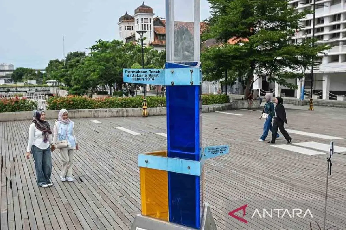
Jakarta’s low-lying and gently sloping topography makes it highly prone to flooding.
Historical records confirm this vulnerability.
The Tugu inscription from the Tarumanagara Kingdom in the 5th century AD, discovered in 1887 in North Jakarta, documents King Purnawarman’s orders to dredge rivers to mitigate flooding.
During the Dutch East Indies era (1872–1918), Batavia (Jakarta) suffered major floods that inundated nearly the entire city, including Weltevreden—now Sawah Besar, Gambir, and Lapangan Banteng.
Beyond flooding, Greater Jakarta also faces seismic risks.
The Baribis Fault, an active thrust fault stretching from Cirebon to Jakarta and Bogor, poses a serious threat due to its shallow earthquake hypocenters.
On August 20, 2025, a 4.9 MMI earthquake in Bekasi highlighted this danger, even disrupting seven schedules of the Whoosh high-speed train.
Similarly, the Depok Blind Thrust, part of the West Java back-arc thrust system, runs beneath southern Jakarta and has historically triggered major earthquakes in 1699, 1780, and 1834.
Jakarta is also vulnerable to potential megathrust earthquakes, which could cause catastrophic damage.
Key Solutions
To anticipate disaster risks in the Greater Jakarta agglomeration, the government must first strengthen river basin management across upstream, midstream, and downstream areas.
Jakarta is traversed by 13 rivers, many of which overflow during heavy rains, contributing to severe flooding.
Effective watershed management, combined with measures to anticipate tidal floods, is essential to reduce the city’s vulnerability.
Equally important is the enforcement of disciplined spatial planning.
Violations of zoning regulations, particularly in watershed and swamp areas, have worsened Jakarta’s exposure to disasters.
A stricter approach to spatial planning would help restore environmental resilience and ensure that development does not compromise the city’s ability to absorb water or withstand shocks.
Another priority is the evaluation of all buildings and infrastructure to ensure they meet safety standards against earthquakes.
Given the presence of active faults such as the Baribis Fault and the Depok Blind Thrust, structural resilience is critical to prevent widespread collapse during seismic events.
Alongside this, evacuation routes and shelters must be prepared in every sub-district to provide safe havens for residents during emergencies.
The government must also develop integrated strategies to address simultaneous disasters.
Floods, tidal floods, fires, and earthquakes often overlap, creating complex emergencies that are difficult to manage.
A coordinated response plan would allow authorities to mobilize resources more effectively and minimize casualties.
Finally, disaster literacy among residents must be continuously strengthened.
Public awareness campaigns, education from an early age, and multi-stakeholder involvement are vital to building a culture of resilience.
Communities that understand risks are better equipped to respond quickly and reduce losses.
Indonesia can draw lessons from Japan, where high public awareness has consistently minimized casualties during disasters.
Greater Jakarta must begin building this culture of preparedness now, before the next major disaster strikes.
*) Andre Notohamijoyo is Assistance Deputy of Disaster Risk Reduction, Coordinating Ministry of Human Development and Cultural Affairs
The views and opinions expressed on this page are those of the author and do not necessarily reflect the official policy or position of ANTARA News Agency.
Copyright © ANTARA 2026


