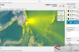
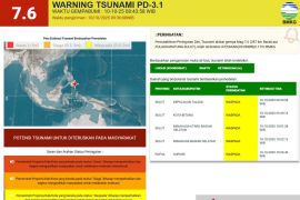
The quake`s epicenter was located 5.29 degrees southern Latitude and 102.47 degrees eastern longitude, at a depth of 10 km below sea level, and around 115 km southwest of Bintuhan, according to the national meteorological, climatology and geophysics office on its official website.
The temblor shocked residents who were soundly asleep, but they returned to their homes few minutes later since there were no aftershocks, Samsudin, a Pagar Dewa resident, said.
Bengkulu province was rocked by powerful quakes measuring respectively 7.3 in 2000 and 7.9 in 2007 on the Richter scale, killing tens of people and destroying thousands of houses.
The National Disaster Management Agency (BPBN) last year declared Bengkulu province a natural-disaster-prone region.
Bengkulu was not only prone to earthquakes but also to tsunamis when an earthquake measuring more than 6 on the Richter Scale occurred, Bengkulu Vice Governor HM Syamlan said last October.
"This is a bitter reality but people should know the facts so that they will remain alert and anticipative," he said.
Experts had predicted that a disaster cycle was likely to occur in the region because an active earth plate movement would happen below Bengkulu Province in 2011-2014
If the earth plate movement was significant, it could cause am earthquake and even tsunami.
All of the district chiefs were expected to anticipate the predicted event by conducting simulations of disaster management frequently and allocating more budget funds for disaster management.
Following the declaration of Bengkulu as a disaster-prone region, residents of Bengkulu were advised to improve their spiritual quality and appreciate and respect other people and nature.
(T. Z005/F001/HAJM/F001)
Editor: Priyambodo RH
Copyright © ANTARA 2011

