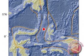
The epicenter of the earthquake, which struck at 05.21 p.m. local time, was located 99 km southeast of Maluku Tengah district, according to the Meteorology, Climatology and Geophysics Board (BMKD).
However, the earthquake did not cause a tsunami.
As a result of the powerful earthquake, panic-stricken people, including residents, hotel guests and those in other buildings preferred to stay outdoors for fear of aftershocks, ANTARA observed.
There was no immediate report of any casualties or material damage.
Maluku is one of the earthquake- and tsunami-prone provinces in Indonesia, situated as it is at the meeting point of three major plates of the Pacific, Indo Australia, and Eurasia.
A powerful 7.1-magnitude earthquake had rocked Maluku in November last year, sparking a tsunami warning and causing panicked people to flee their homes.
Among the earthquake-prone areas in Maluku are Ambon, Seram and Buru islands as well the southeastern part of the province.
More than 17,000 Indonesian islands are scattered along a belt known for volcanic and seismic activity and called the Pacific "Ring of Fire". The islands are one of the most quake-prone areas on earth.(*)
Editor: Heru Purwanto
Copyright © ANTARA 2015


