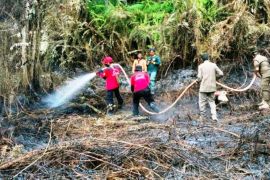
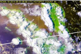
Of the total 159 hotspots, 92 were found in Riau Province, Slamet Riyadi, the head of the Pekanbaru meteorology office, said here on Monday.
The information was released by Indonesias National Institute of Aeronautics and Space (LAPAN), based on the monitoring by the Terra and Aqua satellites.
Other hotspots were found in Bangka Belitung (330), South Sumatra (20), North Sumatra (six), Jambi (four), Bengkulu (two), Lampung (one), and Riau Islands (one).
In Riau, the hotspots were found in nine districts, including Rokan Hilir (54 hotspots), Dumai (15), Bengkalis (eight), and Rokan Hulu (five).
In the meantime, hotspots indicating forest, peatland and plantation fires have been detected in several provinces in Indonesia lately.
Riau, Jambi, South Sumatra, West Kalimantan and Central Kalimantan have declared an emergency alert status in anticipation of land and forest fires, according to the National Disaster Mitigation Agency (BNPB).
"The other provinces prone to land and forest fires are South Kalimantan, East Kalimantan, North Kalimantan and North Sumatra, but they have not declared an emergency status alert," Sutopo Purwo Nugroho, BNPB spokesman, stated.(*)
Editor: Heru Purwanto
Copyright © ANTARA 2016

