Meteorology and Geophysics Office spokesman Andri W Bidang remarked here on Wednesday that the first earthquake measuring 4.0 on the Richter scale jolted the province at 2.37 am Eastern Indonesia Standard Time (WIT).
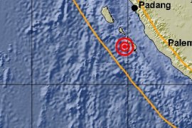
Its epicenter was located at 2.92 degrees Southern Latitude and 134.32 degrees Eastern Longitude on the land, 29 km southwest of Wondama Bay District.
Later at 4.08 am WIT, the second earthquake measuring 5.0 on the Richter scale jolted Tambrauw District.
The epicenter of the second quake was in the sea at the coordinate of 1.16 degrees Northern Latitude and 132.7 degrees Eastern Longitude at a depth of 10 km.
"We call on the people in coastal areas to stay calm because the two earthquake did not have the potential to trigger a tsunami," Andri said.(*)
Editor: Heru Purwanto
Copyright © ANTARA 2017


