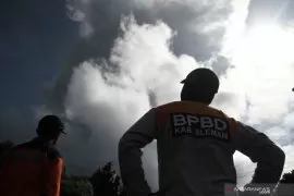
Based on the observation of Mount Merapi from the Babadan Post, Dukun Sub-District, Magelang District, Central Java Province, until 10:45 p.m. local time, smoke continued to arise from fires in a small part of the forest, some three kilometers from the peak of Merapi.
From the local post, the smoke arose from around Klatakan Hills and under Kendil Hills, while Merapi`s peak was clearly visible from the observation post located some 4.4 kilometers southwest of the peak of Merapi. The sky above Mount Merapi also appears bright.
"Fires arose in the forest due to exposure to rocks during eruption this morning," observers` officer of Mount Merapi Triyono remarked.
The emitted hot rocks burnt pine trees in a small part of the forest around the summit of Mount Merapi.
He stated that various tools to monitor Mount Merapi`s activities at various locations at the peak of the volcano are currently still functioning normally.
"All monitoring tools as well as those at the top are still safe," he added.
Merapi`s eruption on Friday at around 8:20 a.m. local time occurred for two minutes, with the smoke column rising to a height of six thousand meters above the peak and drifting in the northwest direction but then the wind changed its direction to the north.
Several areas of Mount Merapi have been exposed to ash, including some villages, such as Wonolelo Village, Ketep Sawangan Sub-District; Sumber Village, Dukun Sub-District; Banyusidi Village, Pakis Sub-District; Sumberejo Village, Ngablak Sub-District, Magelang District; and Jrakah Village, Selo Sub-District, Boyolali District.
Until now, the activity of Mount Merapi is still at the alert status level II.
Reporter: Tessa
Editor: Otniel Tamindael
Copyright © ANTARA 2018