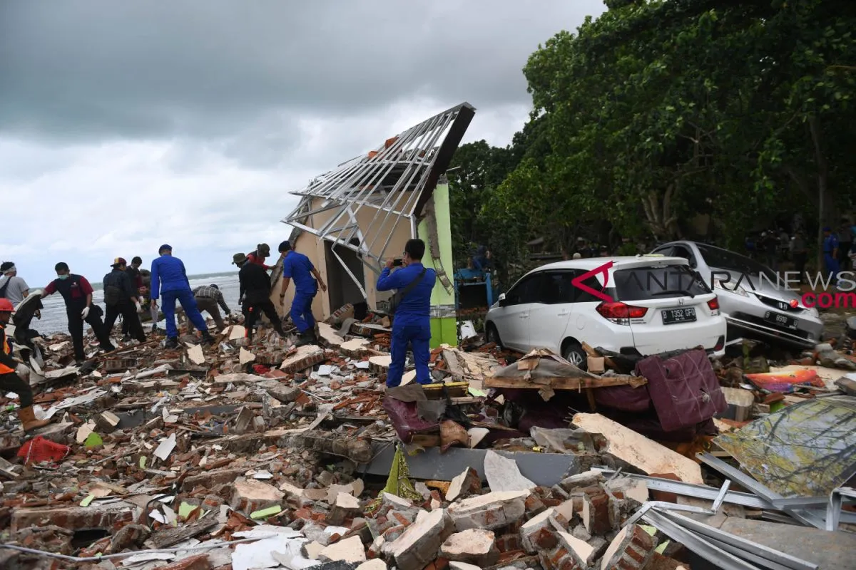
A towering tsunami devastated several regions in the coastal areas of Banten province in Java and South Lampung District in Lampung Province on Saturday (Dec 22), killing at least 334 people.
The tsunami was believed to have been triggered by an avalanche of the slopes of Anak Krakatau volcano explosions in the Sunda Strait that separates the Islands of Java and Sumatra.
The Sunda Strait tsunami happened several months after an earthquake and its subsequent tsunami hit Palu, Central Sulawesi, on Sept 28, killing 2,102 people, and Lombok Island on Aug 5, claiming the lives of 555 residents.
Expressions of condolences are pouring from home and abroad for the victims. Japanese Foreign Minister Taro Kono, Chinese President Xi Jinping, Malaysian Deputy Prime Minister Wan Azizah Wan Ismail, South Korean President Moon Jae-in, and Turkish President Recep Tayyip Erdogan have expressed their condolences.
Anak Krakatau is a small volcanic island located in the Sunda Strait between the islands of Java and Sumatra. It emerged from the ocean half a century after Mount Krakatau`s deadly eruption in 1883, hence the term anak (child) in its name, according to the Jakarta Post.
Anak Krakatau has seen small regular eruptions since June. The volcano was put on the second-highest alert level in 2012, but it had been erupting since some time ago.
It was surprising as the tsunami struck Banten and Lampung on Saturday night (Dec 22) without being preceded by an earthquake and it was believed to have occurred due to volcanic activity of Mount Anak Krakatau.
The Meteorology, Climatology and Geophysics Agency (BMKG) noted that the tsunami, which occurred in the Sunda Strait on Saturday, was caused by the avalanche of the slopes of Mount Anak Krakatau.
"From the observation of satellite imagery, there has been a deformation of 64 hectares of Gunung Anak Krakatau, especially on the southwest slope," BMKG Head Dwikorita Karnawati noted in a statement in Jakarta on Monday.
Deformation or change in shape on the surface of the body of Gunung Anak Krakatau was due to a collapse caused by the vibration or tremor from volcanic activity.
This condition was also exacerbated by extreme weather that occurred in the form of waves and high rainfall. The BMKG had virtually issued an early warning the day before.
"This phenomenon is reinforced by an analysis of four tide gauge models, which show that the tsunami`s energy source originates from the South of Mount Anak Krakatau," Karnawati said.
According to the National Search and Rescue Agency (Basarnas), the death toll from the Sunda Strait tsunami rose to 334 on Monday.
The death toll might increase, as many people were still missing, Fahrizal, spokesman for Basarnas, remarked. Quoting a report received from the field at 11 a.m. local time on Monday, he stated that a total of 764 people were injured, while 61 others were still missing.
The tsunami hit 17 places, including Carita, Panimbang, Cigeulis, Sumur, Labuan, Tanjung Lesung, Cibaliung, Cimanggu, Pagelaran, Bojong, Anyer, Sangiang Island, Menes, Hampeleum Island, Banyuasin, and OSC Lampung, he added.
The tsunami killed 74 people in Panimbang, 70 in Carita, 55 in OSC Lampung, 46 in Tanjung Lesung, 38 in Sumur, and 12 each in Labuan and Anyer.
He remarked that Basarnas, along with relevant agencies, were still searching for other victims at several tsunami-hit places. "We hope that all tsunami victims would be found and identified," he added.
The Sunda Strait tsunami followed two previous tsunamis that occurred in Indonesia over the past few months.
On September 28, 2018, an earthquake and a subsequent tsunami devastated Palu, Central Sualwesi, killing 2,102 people. It also injured 4,612 victims and left 680 others missing.
A total of 68,451 homes were seriously damaged and 78,994 people were displaced. The BMKG initially announced that the earthquake measured 7.7 on the Richter scale, but it later updated the magnitude to 7.4 on Richter scale.
The National Disaster Mitigation Agency (BNPB) confirmed that tsunami waves had struck several parts of Central Sulawesi, namely Talise and Donggala Beaches, after a 7.4-magnitude earthquake hit the province.
"The BNPB confirmed to the BPBD (Regional Disaster Mitigation Agency) that the tsunami hit the Talise coastal area in Palu City and the beach in Donggala," Head of Information Data and Public Relations Center at BNPB Sutopo Purwo Nugroho said in Jakarta.
Before the Palu tsunami, Lombok Island in West Nusa Tenggara Province had earlier faced the same fate when an earthquake with its subsequent tsunami hit several districts in the coastal areas. Before the quake-triggered tsunami, Lombok was struck by a series of earthquakes measuring between 6 and 7 on the Richter scale during the July and August period.
The most severe quake experienced by Lombok was the one that occurred on Aug 5, 2018, with a 7.0-magnitude recorded on the Richter scale.
According to the National Disaster Mitigation Agency, as of Aug 23, at least 555 people had been killed and 829 others were injured. Most fatalities were residents of North Lombok District areas due to their proximity to the strong earthquake`s epicenter. The repeated earthquakes Lombok have also damaged 23,098 houses and led to the forced displacement of 134,236 people.
(A014/INE)
Reporter: Andi Abdussalam
Editor: Heru Purwanto
Copyright © ANTARA 2018