The secrets of our deep sea and oceans remain sealed; and it is our duty to expose and reveal the mysteries and secrets, as well as to study the possible use of living and non-living marine resources to produce new scientific innovationJakarta (ANTARA) - Around 62 percent of the territory of Indonesia, which is strategically located between the Pacific and the Indian oceans, consists of water. The archipelagic nation has a total sea area of 6.4 million square kilometers and a shoreline spanning 108 thousand kilometers.
Despite Indonesia being the largest island country, deep-sea exploration in the country remains limited. Indonesia’s deep seas still hold secrets of marine life, diversity, and resources that are waiting to be uncovered.
According to the National Research and Innovation Agency’s acting director for ship armada management, Nugroho Dwi Hananto, at the global level, up to 80 percent of seas and oceans on the Earth are yet to be properly mapped as continued marine exploration is necessary to make more detailed mapping possible.
The acting director also said that less than 20 percent of Indonesia’s seas have been properly explored and mapped, leaving a significant information gap that necessitates continued scientific exploration and economic exploitation.
The current situation ought to motivate Indonesian researchers to conduct research to obtain information and data on unexplored sea areas that can produce new scientific discoveries, he remarked.
“The secrets of our deep sea and oceans remain sealed; and it is our duty to expose and reveal the mysteries and secrets, as well as to study the possible use of living and non-living marine resources to produce new scientific innovation,” Hananto said.
Related news: BRIN's Sailing Day Program to improve weather, climate forecasts: BMKG
Shallow seas—seas with a depth of less than 200 meters such as the Java and Natuna seas—only constitute 30–40 percent of Indonesia's seas, he noted.
In contrast, around 60 percent of Indonesia's seas have a depth of more than 200 meters—the deepest point in Indonesia is located in Banda Sea, which has a depth of 7,400 meters below sea level, he said.
He highlighted that sophisticated facilities and technology, as well as scientific capability, are a necessity to conduct marine research and surveys to explore Indonesia’s marine potential in unexplored areas.
To help Indonesian researchers to explore Indonesian seas, BRIN has launched the Sailing Day program in 2022 that would provide marine researchers with research funding and facilities free of charge, he informed.
Related news: Three selected marine researches funded through 2022 Sailing Day: BRIN
Inclusive, open access, and facilities
The Sailing Day program is intended to provide open and inclusive access to researchers, university lecturers, and university students to utilize BRIN’s research ships to obtain data and specimens necessary for marine research, BRIN head Laksana Tri Handoko said.
Handoko further said he expected that facilities provided under the Sailing Day scheme—which includes coverage of the cruise cost, onboard accommodation and meals, and technical and operational services of research equipment on board—will motivate Indonesian researchers to conduct marine expeditions and collaborate with domestic and foreign partners to bolster research.
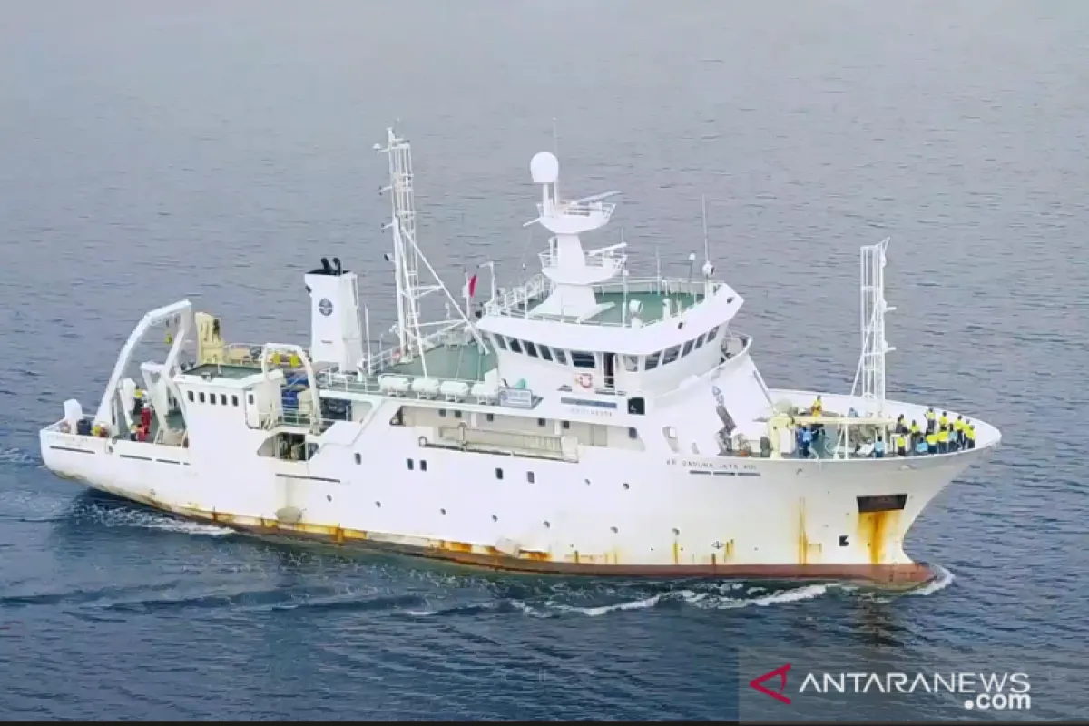
BRIN is currently operating five research ships of which KR Baruna Jaya I is the oldest, followed by KR Baruna Jaya II, KR Baruna Jaya III, KR Baruna Jaya IV, and KR Baruna Jaya VIII, which is the newest vessel in the armada, he informed. Each ship has its own marine research and seabed mapping equipment, he added.
KR Baruna Jaya I was constructed at the French CMN shipyard in 1989, while KR Baruna Jaya VIII was made in the Norwegian Mjellem & Karlsen shipyard in 1998, he said, adding that KR Baruna Jaya I to IV are sister ships due to their same dimensions.
KR Baruna Jaya is equipped with a mounted MBES Teledyne Hydroswept system that can create a seabed map at up to 10 thousand meters depth, while the MBES Kongsberg EM304 system on KR Baruna Jaya III can create a seabed map at 8 thousand meters depth, he informed.
Furthermore, the MBES Elac Seabeam 3050 portable system on KR Baruna Jaya II and IV can create a seabed map at a depth of 3 thousand meters, and KR Baruna Jaya VIII has a mounted MBES Reson system that can map the seabed at a depth of 500 meters, he added.
Related news: Managing Emerald of Equator for sustainable investment
Pioneering researchers
On March 9, 2022, BRIN announced that three research projects will receive the agency’s assistance and funding as part of the first batch of the Sailing Day program.
The first team, helmed by Dr. Ali Budhi Kusuma from Sumbawa University of Technology, will research the biodiversity of extremophilic actinomycetes and their potential for degrading plastic waste. The research will be conducted in the southern part of the Indian Ocean in West Nusa Tenggara.
The output expected from the research is 35 strains of extremophilic actinomycetes obtained from the southern part of the Indian Ocean, two candidate strains that have the potential to be used as agents for microplastic biodegradation, as well as the profile and diversity of microplastics at the research location.
The second research will investigate ocean-atmospheric interactions that trigger the occurrence of extreme storms in the southern waters of Indonesia and will be conducted by Dr. Erma Yulihastin and her team from BRIN’s Aeronautics and Space Research Organization.
Yulihastin’s research will involve the continuous collection of in-situ data on energy instability in the ocean and atmosphere during the transition period between seasons; her research is also expected to serve as the pre-campaign for Years of the Maritime Continent (YMC).
The output expected from her research will be the in-situ data package on the ocean and atmospheric interactions during the cruise period at the research location, a prototype of a mesoscale vortex-eddies interaction identification method, and an international publication.
Related news: Indonesia to raise marine management issue at G20 EDM-CSWG
The third team led by Dr. Hawis Madduppa from Bogor Agricultural Institute will conduct research to reveal the marine diversity in Malacca Strait and investigate the causality with environmental pollution through a thorough exploration and registration of genetic data of organisms identified during the research on national and international databases.
The output expected from Madduppa’s research will be 100 specimens of marine organisms and 40 samples of seawater.
As the three researchers commence their endeavor, they will motivate other Indonesian researchers to utilize any opportunities, including those provided by BRIN’s Sailing Day program, to advance marine research to reveal more of Indonesia's deep-sea secrets and enhance our knowledge of our own sea, observers said.
Related news: Several challenges can potentially rattle recovery path: Minister
Related news: IKN becomes breakthrough to realize Indonesia's Vision 2045: BIN
Editor: Fardah Assegaf
Copyright © ANTARA 2022