"We remind policymakers, communities and all components in each (of the southern coastal) areas to increase preparedness and vigilance to mitigate the potential impact of earthquake and tsunami," the Acting Head of the BNPB Disaster Data, Information, and Communication Center, Abdul Muhari, said in a press statement received here, Sunday.
BNPB hopes that the Earthquake and Tsunami Disaster Resilient Village (Destana) set up in 2019 along the southern coast of Java Island can continue to become a pioneer of community resilience in handling disasters.
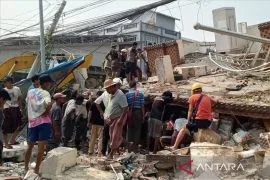
This idea follows a series of earthquakes that hit the southern part of Java Island, including an earthquake of magnitude 5.4 in East Java's southern part on Saturday, July 9, at 03.17 local times.
According to the monitoring results of the Meteorology, Climatology and Geophysics Agency (BMKG), the earthquake was centered 9.64 degrees southern latitudes and 112.91 degrees eastern longitude at a depth of 10 kilometers.
"The Lumajang District Regional Disaster Mitigation Agency (BPBD) reported to the Center for Control and Operations (Pusdalops) of BNPB, that most of the people in Lumajang District suddenly woke up and fled their homes when the earthquake shook for 2-3 seconds," Muhari informed.
Related news: Quakes felt in East Java's 10 districts, cities
Less than three hours after the magnitude 5.4 earthquake, BMKG issued another earthquake information at 05.50 local times. The second earthquake of magnitude 5.0 was centered 9.57 degrees southern latitude and 113.93 degrees eastern longitude at a depth of 10 kilometers. No shock was felt by the community for the aftershock.
At 09.53 local times, the BMKG seismograph recorded another earthquake with a magnitude of 5.3 located at 9.61 degrees southern latitude and 112.91 degrees eastern longitude at a depth of 42 kilometers. According to the Lumajang District BPBD, the shocks of the third earthquake were felt for one to two seconds, but did not cause panic among residents.
The results of an interim analysis by BMKG showed that the series of earthquakes were shallow earthquakes due to plate subduction activity. The results of the analysis of the source mechanism showed that the earthquake has a thrust fault mechanism.
Based on BMKG records as of 11.00 local times, there have been 54 aftershocks with the largest magnitude, M 5.0. From the entire incident of the earthquake phenomenon, BMKG ensured that the earthquake did not have the potential for a tsunami.
"The results of monitoring in the field by the Lumajang District BPBD and Malang District BPBD stated that no damage was caused. There were also no reports of casualties," he confirmed.
Based on the earthquake risk assessment index from InaRisk BNPB, the southern region of Java Island has a moderate to a high level of risk. The southern region of Java Island has also been known to be traversed by the Indo-Australian plate which stretches from the tip of the western part of Sumatra Island to the waters of Southeast Maluku, before finally meeting the Eurasian plate and the Pacific plate.
The earthquake phenomenon may cause several fatalities by the ruins of buildings during strong earthquake shocks. For this reason, strengthening the building structure, especially the pillars of the house and the roof structure, needs to be carried out in stages, both independently and supported by village funds.
Related news: No reported damage despite multiple earthquakes striking E Java: BPBD
Related news: Quakes felt in East Java's 10 districts, cities
Translator: Devi Nindy Sari R, Resinta S
Editor: Suharto
Copyright © ANTARA 2022