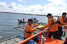
At 4 p.m. WIT (Eastern Indonesia Standard Time), MV Sabuk Nusantara 71 will depart from Yos Sudarso Ambon Port to bring the aid to Dawera Island and Dawelor Island.Ambon, Maluku (ANTARA) - The Maluku provincial government sent two tons of rice assistance to several areas affected by the 7.5-magnitude (M) earthquake that struck at 2:47 a.m. Eastern Indonesia Standard Time (WIT) on Tuesday.
"At 4 p.m. WIT (Eastern Indonesia Standard Time), MV Sabuk Nusantara 71 will depart from Yos Sudarso Ambon Port to bring the aid to Dawera Island and Dawelor Island," Head of the Maluku Provincial Regional Disaster Mitigation Agency (BPBD) Ismael Usemahu stated here on Tuesday.
Usemahu conveyed the information after attending a coordination meeting between the Maluku Provincial BPBD as well as related regional governmental apparatus institutions (OPDs) and Disaster Mitigation Implementation Unit (Satlak PB) from several districts and cities.
In addition, the provincial government distributed blankets and medical assistance to the residents of Dawera Island and Dawelor Island, Dawelor Dawera Sub-district, Southwest Maluku District, who were displaced, as their homes were heavily damaged.
The aid was provided by the province’s Health Office and Social Affairs Office.
In connection with the disbursement of assistance, the BPBD has coordinated with the Satlak PB of Southwest Maluku District and the local sub-district heads to get the aid from the ship and distribute it directly to the affected people.
Tanimbar Islands District and Southwest Maluku District were the most affected areas due to the earthquake, though the recent report indicated no casualties.
"We will submit the latest data (on the impacts of the quake) after a follow-up coordination meeting has been held with related OPDs in districts and cities. Thus, the post-disaster mitigation attempt, such as the rehabilitation and reconstruction, can be followed up,” Usemahu explained.
He noted that the related OPDs included the Health Office, Housing and Settlement Office, Social Affairs Office, as well as Public Works and Spatial Planning Office.
The Meteorology, Climatology, and Geophysics Agency (BMKG) stated that the epicenter of the earthquake was located at sea, some 136 kilometers (km) to the northwest of Southwest Maluku District, Maluku Province, at a depth of 130 km.
The BMKG had issued a tsunami early warning for residents of the provinces of Maluku and Southeast Sulawesi due to the disaster.
However, there were no significant changes in sea level, so the warning was called off.
Related news: City, district police should handle quake impacts: Maluku Police Chief
Related news: Maluku quake damages 15 houses in Tanimbar Islands - BNPB
Translator: Daniel Leonard, Uyu Liman
Editor: Rahmad Nasution
Copyright © ANTARA 2023


