We expect the residents to comply with (the appeal regarding) the dangerous zones or recommendations issued by the PVMBG.Manado, N Sulawesi (ANTARA) - The Volcanology and Geological Disaster Mitigation Agency (PVMBG) has reported that the status of Mount Karangetang in Siau Tagulandang Biaro (Sitaro) Islands District, North Sulawesi Province, remains on alert level III.
"We expect the residents to comply with the appeal regarding the dangerous zones or recommendations issued by the PVMBG," Head of the Karangetang Volcano Observation Post Yudia Tatipang said here on Sunday.
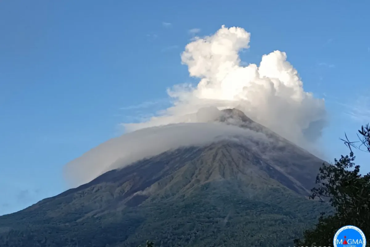
He noted that according to the observation conducted from 00 a.m. to 06 a.m. Central Indonesia Standard Time (WITA) on Sunday, the mountain was clearly visible, although sometimes it was covered by the fog.
During the monitoring period, light to medium-white, weak-pressure smoke was seen out of the main crater, reaching a height of 50 meters (m), he stated.
Meanwhile, thin to thick white smoke came out of the secondary crater, with a maximum thickness of about 25 m.
In addition, the surveillance cameras (CCTVs) captured the visual of flames that erupted at a height of 10 m from the tops of the main and secondary craters.
Furthermore, the Karangetang Volcano Observation Post recorded seven hybrid volcanic earthquakes with an amplitude of 5-8 millimeters (mm) and a duration of 10–24 seconds, as well as a shallow volcanic quake with an amplitude of 8 mm and a duration of 5 seconds.
In addition, the post also recorded one local tectonic earthquake with an amplitude of 35 mm and a duration of 20 seconds and four distant tectonic earthquakes with an amplitude of 8–35 mm and a duration of 44–89 seconds.
Tatipang appealed to the community, tourists, and climbers not to carry out any activity in the areas within a 2.5-kilometer radius of the main crater and a 3.5-kilometer radius of the peak in the south and southeast sectors of the volcano.
Residents near the mountain are also asked to remain calm and not be provoked by false information regarding the eruption of the volcano.
The public should always comply with the recommendations from the North Sulawesi Provincial Regional Disaster Mitigation Agency (BPBD) and Sitaro Islands District BPBD.
Furthermore, people who live along the banks of the river, which originates from the peak of Mount Karangetang, must stay vigilant to the potential lahar flow during the rainy season.
The volcano, which had a height of 1,784 meters (m), had an effusive eruption on February 8, 2023, after showing increasing volcanic activity.
Related news: Mount Anak Krakatau spews ash columns several times on Tuesday
Related news: Mount Merapi spewed lava avalanches 160 times on Mar 17-23
Related news: Mount Semeru shows activity with 21 eruption earthquakes: Official
Translator: Karel Polakitan, Uyu Liman
Editor: Azis Kurmala
Copyright © ANTARA 2023


