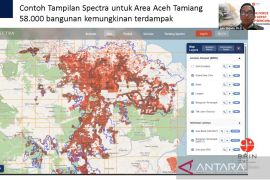
"TRIGRS is an application to determine the parameters that affect slope stability so that the data can be used to determine the vulnerability of the land in an area," BRIN researcher Khori Sugianti noted in a statement from BRIN in Jakarta, Monday.
Sugianti explained that TRIGRS is a software developed by the United States Geological Survey (USGS), which was then further developed through collaboration with BRIN.
Through the technology, she elaborated that her modeling showed the influence of rainfall intensity on slope stability.
"TRIGRS modeling shows that an increase in rainfall intensity can affect slope stability, with changes in the stability of stable slopes to unstable slopes and a decrease in the safety factor value. We conducted research in the Lembang area and its surroundings," she stated.
Sugianto assessed that the TRIGRS model is quite good at predicting slope stability due to rain in landslide-prone areas. This is because landslide inventory data is a factor that influences the success of the TRIGRS model in the model validation process.
Hence, she is optimistic that stakeholders in landslide-prone areas, especially in Lembang, West Java, where her research is centered, will consider her findings.
"We hope for collaboration with various parties in the Lembang area and its surroundings, such as the local government and related agencies, to be able to implement this innovation as a form of landslide disaster mitigation in the future," Sugianti affirmed.
Speaking in connection with this, Acting Head of the West Java Regional Disaster Management Agency (BPBD) Anne Hermadianne Adnan welcomed the collaboration efforts, as West Java is one of the regions in Indonesia that has a fairly high potential for disasters.
"Hopefully, this collaboration activity can be one way to mitigate so that when a disaster occurs, there will be zero victims," Adnan remarked.
Translator: Sean Filo Muhamad, Cindy Frishanti Octavia
Editor: Aditya Eko Sigit Wicaksono
Copyright © ANTARA 2024
