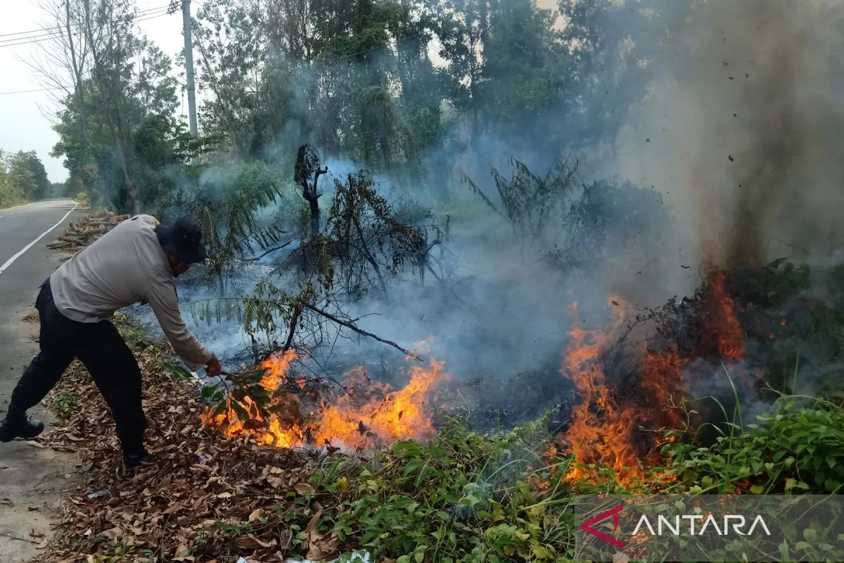
In the first half of 2025, some 12 districts and cities in Riau Province were affected by fires, resulting in a dense haze, unbreathable air, and numerous suspects named as violators of the law.
Latest data showed that as of July 20, 2025, at least 269 hectares of land had burned across 35 forest and land fires (karhutla).
Some 44 people had been named as suspects, including perpetrators who set the fires, financiers, and individual owners who deliberately started fires on their properties.
The fires spread across Kampar, Rokan Hilir, Rokan Hulu, Indragiri Hulu, and Kuantan Singingi districts.
In Rambah Samo, Rokan Hulu District, 143 hectares of limited production forest (HPT) were intentionally burned to clear land for oil palm plantations. Hotspots were also detected in peatland areas and around Tesso Nilo National Park.
"This is not a purely natural disaster. Most of the fires were caused by human activity," Suharyanto, head of the National Disaster Mitigation Agency (BNPB), remarked on July 22.
The pattern and nature of the fires point to land-clearing motives. In a single day, the burned area in Riau can double, growing from 546 to nearly one thousand hectares.
The forest and land fires in Riau this year are seen not only as an ecological disaster but also as a monitoring and enforcement crisis. According to BNPB data as of mid-July 2025, Kampar and Bengkalis have experienced the largest burned areas, each exceeding 100 hectares, followed by Rokan Hilir, Siak, and Indragiri Hilir, with more than 50 hectares each.
Fires in Pekanbaru City cover 21.08 hectares, an increase of six hectares from last week's reported incident, and the fires continue burning in affected areas.
The central government, through the Law Enforcement Task Force, has responded swiftly by indicting 44 suspects. However, fires continue to spread, and haze threatens to cross borders.
There remains uncertainty about the suspects’ legal consequences, whether they will face administrative sanctions, criminal charges, or imprisonment.
Furthermore, authorities have not yet taken action against concession holders, who are frequently mentioned in field reports.
According to Environment Minister Hanif Faisol Nurofiq, several large companies, including RAPP, Sinar Mas Group, and PTPN IV Regional III, have been instructed to strengthen their commitment to preventing forest and land fires by ensuring canal barriers are built, fire extinguishers are available, and actively patrolling in the fields is conducted.
The fire patterns tend to follow a similar trajectory, starting at the borders of plantation concessions, spreading into community-owned land, and then entering protected areas. During the dry season, when the land begins to dry out, burning becomes an inexpensive and quick shortcut for land clearing.
Matches have replaced tractors and heavy equipment. A single log of wood burned can clear a hectare of new land, transforming it into a planting-ready expanse within days.
In addition to individual perpetrators, fires are found around concession areas owned by large corporations, suggesting a massive and systematic burning pattern.
Related news: VP updated on 51 detained Riau fire suspects
Forest and Land Fires Desk
The central government has activated the Forest and Land Fires Desk, a cross-sectoral task force responsible for managing forest and land fires in seven vulnerable provinces, including Riau. Operational support includes funding, logistics, and ground and air firefighting equipment.
The stipulation of this desk is based on Presidential Instruction Number 3 of 2020 and Coordinating Minister for Political, Legal, and Security Affairs Decree Number 29 of 2025. The Coordinating Ministry for Political, Legal, and Security Affairs (Kemenko Polkam) and BNPB have been appointed as primary agencies in handling forest and land fires.
As mandated by President Prabowo Subianto, the BNPB is responsible for providing support and guidance for forest and land fire management, commanding resources for forest and land fire management, collaborating on socio-economic improvement activities, and providing support to the Ministry of Forestry and the Ministry of Environment in resolving overlapping regulations.
Meanwhile, the Coordinating Ministry for Political, Legal, and Security Affairs is tasked with ensuring the orderly execution of the Forest and Land Fires Desk duties in accordance with statutory provisions and carrying out other duties assigned by the steering and control chair.
However, policy in the field remains limited, especially in remote areas with difficult terrain.
Between mid-May to June 2025, atmospheric dynamics caused unstable weather patterns, with the dry season arriving, albeit accompanied by rainfall in several locations. Such a situation is rather perplexing, as one province is experiencing floods and landslides, while others have been severely burned.
The seven priority provinces are Riau, South Sumatra, Jambi, West Kalimantan, Central Kalimantan, South Kalimantan, and the Indonesian Capital City (IKN) of East Kalimantan.
From January to July 20, some 790 hotspots and 27 active fires were detected in Riau alone. This emergency situation requires more than a conventional approach based solely on ground fire suppression methods.
The BNPB has deployed water-bombing helicopters, with some provided by private companies. Weather Modification Operations (OMC) have also been intensified since May and resumed on July 21 for the next five days. Results are emerging, although not evenly distributed. Weather-modified rain has begun to fall in areas such as Indragiri Hilir, Kuala Kampar, and Bangkinang.
However, the challenges remain consistent: deep, inaccessible peatlands; underground fires burning; and strong winds that accelerate fire spread. Several districts have declared alert status, but there is no evacuation mechanism in place if air quality worsens.
Air quality has already deteriorated in several areas. In Rokan Hilir and Pelalawan, residents have begun wearing N95 masks outdoors. Schools are also preparing to implement distance learning if cases of respiratory infections arise. To date, no official health emergency policy has been issued by the local government.
Forest and land fires are a multidimensional crisis threatening ecology, health, the economy, and international diplomacy. In the context of global climate change, Indonesia risks its reputation and commitments.
Indonesia has faced a persistent pattern of forest and land fires for two decades, particularly in high-risk areas such as Riau, Jambi, South Sumatra, and Kalimantan. The year 2015 was one of the worst, with 2.6 million hectares of land burned and smoke even reaching neighboring countries.
A significant spike occurred again in 2019. According to data from the (formerly) Ministry of Environment and Forestry, over 857 thousand hectares were burned, with Central Kalimantan and Riau as the epicenters of the fires. Of this, 328 thousand hectares were peatland, which is extremely difficult to extinguish.
In 2023 and 2024, hotspots decreased due to rainfall and the implementation of early detection technology. However, a rise appeared in early 2025, signaling that long-term approaches, such as peat ecosystem restoration and forest concession permit restructuring, have not been optimally implemented. Without serious improvement, Indonesia may fall back into a destructive five-year cycle of land and forest fires.
Related news: Indonesia wildfires burn 8,500 hectares, mostly human-caused
Related news: Cross-sector collaboration helps Indonesia control land fires
Related news: National concern grows as North Sumatra fires persist
Translator: M. Riezko Bima, Resinta Sulistiyandari
Editor: M Razi Rahman
Copyright © ANTARA 2025


