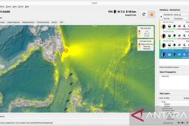
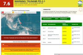
Meteorology, Climatology and Geophysics Agency (BMKG) reported that epicenter of the earthquake was located 6.39 degrees southern latitude and 130.92 degrees eastern longitude at a depth of 115 kilometers.
BMKG said the epicenter was located 181 kilometers northwest of Saumlaki, 218 kilometers southwest of Tual, 414 kilometers southwest of Fakfak, 433 kilometers southeast of Ambon, and 2,676 kilometers southeast of Jakarta.
Earlier on Tuesday morning, a 5.0 magnitude undersea earthquake also hit Tual but there was no immediate report of casualties or material damage.
The epicenter of the undersea quake which struck at 00.08 a.m. Western Indonesia Time was located 6.47 degrees southern latitude and 131.69 degrees eastern longitude at a depth of 62 km, the Meteorology, Climatology and Geophysics Agency (BMKG) said in its official website.
The quake was not strong enough to trigger a tsunami, it said.
Indonesia sits on the Pacific "Ring of Fire" where the meeting of continental plates causes high volcanic and seismic activity.
Maluku province lies at the meeting point of the country`s two main chains of volcanoes.
Tuesday`s temblor was the latest in a series of moderate quakes that hit the country in recent weeks.
On Monday night, a quake measuring 5.3 on the Richter scale struck Nabire in the country`s easternmost province of Papua. The quake was centered 12 km northeast of Nabire at a depth of 50 km. However, there was no immediate report of casualties or material damage.
The agency said earlier two quakes measuring respectively 3.6 and 4.1 on the Richter scale hit Kendari, capital of Southeast Sulawesi province, on April 25, injuring scores of people and causing damage to a number of houses.
On April 29, a 6.0-magnitude quake struck Aceh province, prompting many people to rush outdoors. But there was no immediate report of casualties or material damage.
(Uu.O001/H-NG )
Editor: Priyambodo RH
Copyright © ANTARA 2011

