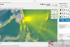
On March 19, 2012 at 2.23 am local time a quake struck with a magnitude of 4.2 on the Richter scale 33 kilometers southeast of East Luwu, South Sulawesi, 2.45 degrees southern latitude and 121.41 degrees eastern latitude in a depth of 10 km.
A tectonic quake with a magnitude of 4.2 on the Richter scale struck on the same day at 9.19 am local time, with its epicenter in a depth of 20 kilometers southeast of Bantul 8.09 degrees southern latitude and 110.3 degrees eastern longitude in a depth of 10 km.
Then on the same day at 12.05 local time a tectonic quake with a magnitude of 4.9 on the Richter scale struck Palu with its epicenter some 18 km southwest of Palu 0.72 degrees southern latitude and 119.89 degrees eastern longitude in a depth of 32 km.
On March 20, 2012, at 7.01 am local time a quake with a magnitude of 4.8 on the Richter scale shook part of Kendari in the sea some 96 km southeast of North Konawe 3.68 degrees southern latitude and 123.14 degrees eastern longitude in a depth of 34 km.
"Also on March 20, 2012 a tectonic quake shook with a smaller magnitude of 3 on the Richter scale," the BMKG analyst of the Pekanbaru meteorological station Ardhitama said.
The quake struck on land some 42 km southwest of East Sumba 9.43 degrees southern latitude and 120.19 degrees eastern longitude in a depth of 70 km.
On March 21 and 22, 2012, Ardhitama said quakes of a magnitude of 6.3 and 5.2 on the Richter scale shook part of Sulawesi and Sangihe Islands.Â
(H-NG/O001)
Editor: Ade P Marboen
Copyright © ANTARA 2012

