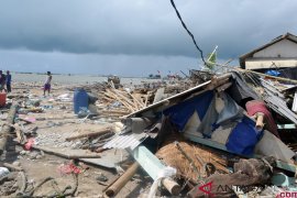
Based upon an analysis from the Pacific Disaster Center, a tsunami reaching a height of between 0.3 and one meter is expected to reach eastern Indonesian coastal areas, Sutopo Purwo Nugroho, BNPB spokesman, said here on Saturday.
Within a half hour, the tsunami would reach the coasts of Manado (North Sulawesi Province) and Ternate (North Maluku Province), and one or two hours later could threaten Maluku, Papua and Central Sulawesi Provinces.
He also confirmed that a tsunami alert was declared for Halmahera in North Maluku Province, Talaud and South Bolaangmongondow in North Sulawesi Province.
"People in those areas have felt the strong earthquake," he said, adding that his office has informed local residents about the possible tsunami and issued directives.
The 7.3-magnitude earthquake rocked North Maluku on Saturday at 09:31 am Western Indonesian Standard Time (WIB). The quakes epicenter was located 1.95 degrees northern latitude and 126.46 degrees eastern longitude, at a depth of 48 Km, some 137 km northwest of West Halmahera.
The epicenter was also located about 156 km southeast of Ternate, and 180 km northwest of Sofifi, the capital of North Maluku.
The powerful quake prompted the residents of Ternate to scramble from their homes.
There were no immediate reports of fatalities or property damage.
Being the worlds largest archipelago, Indonesia is prone to earthquakes due to its location on the Pacific "Ring of Fire," an arc of volcanoes and fault lines in the Pacific Basin.
On December 26, 2004, a gigantic tsunami, triggered by a greater than 9-magtitude earthquake, devastated Aceh Darussalam Province and Nias (North Sumatra Province), killing some 230 thousand people and leaving one million homeless.
(Uu.F001/INE/KR-BSR/O001)
Editor: Priyambodo RH
Copyright © ANTARA 2014


