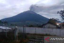
"After the quake the activity of Mount Kerinci is increasing. Since Friday grey smoke has been seen billowing from its peak up to 500 meter high eastward and westward," the spokesman of the National Disaster Mitigation Agency (BNPB), Sutopo Purwo Nugroho, said in a press release received here.
According to the Volcanology and Geological Disaster Mitigation Center (PVMBG) continuous tremor at an amplitude of 0.5 millimeter to 2 millimeter or dominantly 1 millimeter has been recorded.
Sutopo said the amplitude was not too big compared to that during the eruption of Mount Bromo or Mount Raung which was at around 30 millimeter.
"It means it is not too big and so not worrying," he said.
The eruption of Mount Kerince has caused thin ash rain in the village of Sungai Sikai and the village of Tangkil in the sub-district of Gunung Tujuh, Kerinci district, Jambi province.
It has happened tens of times and continuously. The danger status has not been raised meaning it remains at Level II established since September 9, 2007.
PVMBG has recommended against entering the three kilometer radius of the mountains crater.
"Mount Kerinci is the highest in Sumatra which is at 3,805 meter above the sea level and in view of that planes are advised to avoid routes around Mount Kerinci," Sutopo said.
He said people are advised to remain calm as no evacuation is needed as the red zone is still within a radius of three kilometers from the peak while the residential areas are around eight kilometers from the peak.
"People are safe and can carry out their daily activities normally. The regional office of disaster mitigation agencies of Kerinci district and Jambi province as well as other elements have already prepared contingency plans in case increasing activity is recorded from the mountain," he said.(*)
Editor: Heru Purwanto
Copyright © ANTARA 2016

