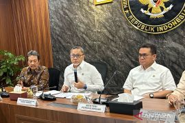
The updated Indonesian map has also implemented the international arbitration court`s ruling on South China Sea dispute between China and the Philippines.Jakarta (ANTARA News) - The government has established the newly updated Indonesian map after a series of discussions since Oct 2016, an official of the Coordinating Ministry for Maritime Affairs said.
The updated map includes some changes and improvements based on the international law on maritime boundaries with neighboring countries, the ministrys deputy on maritime sovereignty Arif Havas Oegroseno stated here on Friday.
"There are some factors behind these changes, including the newly signed boundary agreement between Indonesia and Singapore that had already been ratified by the parliament," he noted.
The agreement on maritime boundary with the Philippines on the overlapped economic exclusive zone in Sulawesi Sea and Mindanao Sea had also been ratified.
"It would take effect soon," he added.
The updated Indonesian map has also implemented the international arbitration courts ruling on South China Sea dispute between China and the Philippines.
"The ruling has an international law jurisprudence which states that small island or coral island in the sea that is not part of an islands country will not deserve the 200 miles of the economic exclusive zone," he remarked.
Changes were also made in the Malacca Strait map, with simplification on its boundary to ease law enforcement and sea monitoring.
"And in the area close to Indonesia and Singapore, we have a clear boundary, and this has to be included in the updated map," Havas explained.
The last update of the Indonesian map was in 2005. The map would need further update to adjust with developments reached with neighboring countries on border agreements.
"We have to continuously update the map. We would submit the updated map and the agreed boundaries to the UN," he revealed.
The map update was conducted by representatives of 21 state institutions.
The Coordinating Ministry of Maritime Affairs would soon disseminate the updated Indonesian map to other institutions.(*)
Editor: Heru Purwanto
Copyright © ANTARA 2017
