As an effort to reduce the disaster risk, we had managed the monitoring and management of watersheds (DAS), cleaning garbage and other materials clogging the water flow, monitoring the condition of embankments, and monitoring roads and bridges in coaJakarta (ANTARA) - The National Disaster Mitigation Agency (BNPB) reported that almost all districts and cities along the North Coast (Pantura) of Central Java were affected by coastal flooding and tidal waves that had occurred since May 23.
"The BPBD team focuses on reducing the disaster risk and minimizing the impact of a follow-up disaster by building temporary wave barriers, cleaning river obstructions, and normalizing river banks," Acting Head of the BNPB Disaster Data, Information, and Communication Center Abdul Muhari noted in a written statement on Friday.
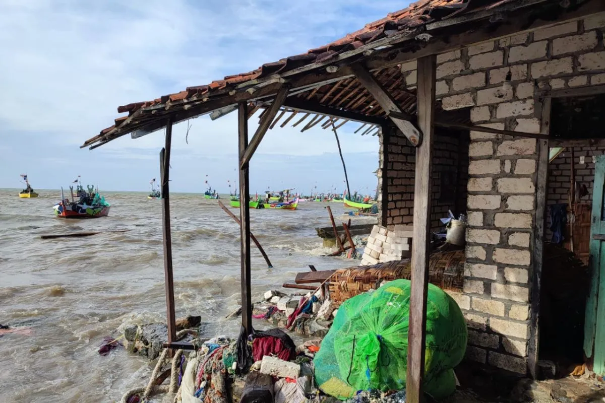
Based on data as of May 25, the areas affected by coastal flooding are Brebes District, Tegal District, Tegal City, Pemalang District, Pekalongan District, Pekalongan City, and Batang District, Kendal District, Semarang City, Demak District, Jepara District, Pati District, and Rembang District.
Related news: For sustainable tourism, industry needs to help tackle disasters:
According to data on May 24, four villages in Brebes District were affected by coastal flooding, with water levels rising to heights of 10-20 centimeters. Four sub-districts in Tegal were also submerged by coastal floods, with waters reaching a height of 45 centimeters.
Meanwhile, Dampuak Village in Tegal District was reportedly submerged in waters reaching heights of 40-100 centimeters.
In Pekalongan City, the water level was reported between 10 and 90 centimeters, thereby forcing 221 residents to evacuate. Meanwhile, in Pekalongan District, four villages were submerged by coastal floods, with water levels reaching heights of five to 40 centimeters.
Eight villages in Pemalang District were also inundated by floods, with water levels of 30-100 centimeters. In Batang District, the water level reached 40 centimeters, thereby affecting 1,874 residents in five villages and two sub-districts.
Related news: Indonesia paying attention to accommodating Sendai framework: official
In Semarang City, the water level reached more than one meter after the seawater embankment collapsed, as it was unable to accommodate the rising waves.
In Demak District, the floodwaters reached 25-100 centimeters and affected approximately 10 thousand residents, with water levels reaching heights of 25-100 centimeters. In Jepara District, the flood level only reached about 500 meters from the shoreline and submerged residential areas, with water levels of 10-20 centimeters.
Muhari noted that Pati District bore the maximum brunt of coastal flooding since it affected six villages in Dukuhseti Sub-district, six villages in Tayu Sub-district, and six villages in Margoyoso Sub-district, five villages in Trangkil Sub-district, and three villages in Juwana Sub-district.
In Rembang District, as the easternmost district in the northern part of Central Java, at least nine villages, with 119 families are affected, while 11 residents are displaced.
As a precautionary measure against further disasters, Muhari stated that the regional disaster mitigation agency (BPBD) had set up evacuation tents and readied disaster emergency posts and public kitchens as well as deployed a team to help accelerate disaster mitigation steps.
"As an effort to reduce the disaster risk, we had managed the monitoring and management of watersheds (DAS), cleaning garbage and other materials clogging the water flow, monitoring the condition of embankments, and monitoring roads and bridges in coastal areas," he noted.
Related news: House Speaker highlights parliament role in disaster risk reduction
Related news: KSP asks varsities, NGOs to speak up on disaster handling issues
Translator: Hreeloita Dharma S, Resinta S
Editor: Fardah Assegaf
Copyright © ANTARA 2022


