Head of the Center for Groundwater and Environmental Geology, Rita Susilawati, stated on Tuesday that the subsidence of land was due to the characteristics of the soil and rocks caused by natural consolidation.
Regarding the effect of land subsidence, Susilawati said her side still required a comprehensive study from cases of groundwater extraction.
Based on data from the Geological Agency, geological characteristics in the Pekalongan, Semarang, and Demak areas mostly comprised soft soil deposits that are usually prone to land subsidence.
"From the 30 locations of coastal flooding, soft soils consisted of early alluvial rocks that had not been consolidated," Susilawati noted in a press conference.
Related news: Pantura's most areas affected by coastal flooding, tidal waves: BNPB
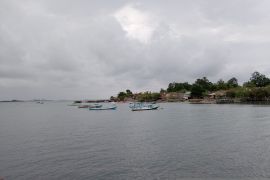
Coastal flooding, with water levels reaching a height of more than two meters, had submerged the coastal side of Semarang, Rembang, Pati, Demak, Pekalongan, and Tegal.
The natural disaster submerged thousands of houses and paralyzed the community's economic activities.
Secretary of the Geological Agency Ediar Usman drew attention to the development and use of land on the North Coast of Central Java that currently lies on unconsolidated soil and sediment.
However, in such areas, such as residential ones, land subsidence will occur faster due to a load on the land that leads to faster compaction, Usman added.
"If there is sedimentation, then there will be compaction consolidation. Heavy load above the ground will accelerate compaction and land subsidence. The area will then be prone to coastal floods," he stated.
He further advised that the development of cities in coastal areas must be conducted with a more thorough engineering system since the land has not been consolidated, especially in alluvium deposits, swamps, lakes, and others.
Related news: Ministry carries out emergency handling after coastal flood in Pantura
Translator: Sugiharto Purnama, Resinta S
Editor: Suharto
Copyright © ANTARA 2022

