"There is no tsunami impact, and the sea level does not show an increase as well. There is a sea level observation tool, and it is stated that there is no significant change in sea level," Deputy for Geophysics at BMKG Suko Prayitno Adi stated at a virtual press conference on Post-Earthquake Development in Aceh, followed here, Saturday.
Adi noted that the earthquake was triggered by the subduction activity of the Aceh-Andaman Megathrust plate, in line with an active Megathrust activity in the western region of Sumatra.
Based on observations of the epicenter and the depth of the hypocenter, the earthquake that struck was a type of shallow quake that had a thrust fault mechanism, Adi explained.
He said the estimated shock level map reached the Modified Mercalli Intensity (MMI) IV-V intensity scale that had the potential to cause damage.
As of 09:00 local time, Saturday, Adi had yet to receive reports of victims of the incident.
"If we look from the intensity, the possibility of damage is only minor. So far, no casualties have been reported," he remarked.
The BMKG reported that the earthquake was felt at MMI IV in the Meulaboh, South Aceh, and Nagan Raya areas.
The earthquake was also felt at MMI III by people in Aceh Besar, Banda Aceh, Takengon, Bener Meriah, and Simeulue.
"The earthquake felt like a truck passing by," he stated.
He remarked that the earthquake was also felt at MMI II in Pidie, Idi, Bireun, Langsa, and Aceh Tamiang.
"Several people felt the earthquake. Light objects that were hung also swayed. So far, there have been no reports of damage caused by the earthquake," Adi remarked.
As of 08:10 local time, the BMKG monitoring results indicated two aftershocks, with the largest magnitude of 2.7.
The agency reminded the public to remain calm but alert since aftershocks are likely to occur.
"People whose houses have been damaged or partially damaged are advised not to stay at home. Buildings can suffer more serious damage and even collapse caused by aftershocks," Adi stated.
He also warned the public to be wary of hilly areas, with steep cliffs, as significant aftershocks could trigger landslides and rock collapse.
"People are urged to not believe fake news about predictions of a bigger earthquake and a tsunami," Adi pointed out.
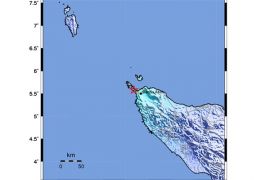
As earlier reported, a tectonic earthquake, with a magnitude of 6.4, at 03:53 local time, with the epicenter of 3.75° North Latitude; 95.97° East Longitude, at sea, 46 kilometers to the southwest of Meulaboh, Aceh Barat, at a depth of 53 kilometers, rocked the Aceh west coast.
Aceh had a history of a major earthquake that triggered a tsunami on December 26, 2004, with a magnitude of 9 that resulted in 283,100 people being killed, 14,100 people going missing, and 1,126,900 people being displaced.
Another earthquake struck on March 28, 2005, with a magnitude of 8.6, resulting in 1,303 people being killed, more than 340 people being injured, and more than 300 buildings being damaged.
On April 7, 2010, the BMKG recorded an earthquake of magnitude 7.6 that resulted in five being seriously injured, 17 lightly injured, 64 houses severely damaged, 275 houses moderately damaged, and 824 houses lightly damaged.
Related news: Residents flee homes after earthquake hits Mentawai Islands: BPBD
Related news: 5.3 M aftershock follows 6.2 M earthquake in Mentawai Islands
Related news: Earthquake of magnitude 6.0 strikes Papua's Mamberamo
Translator: Andi Firdaus, Resinta S
Editor: Sri Haryati
Copyright © ANTARA 2022


