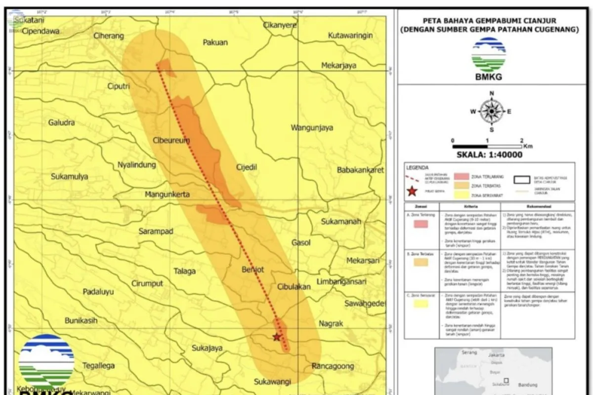
Based on the official BMKG statement received here on Monday, the map is divided into three zones of vulnerability to ground movement, comprising forbidden zone (red), restricted zone (orange), and conditional zone (yellow).
The forbidden zone, with an area of 2.63 square kilometers, covers four sub-districts and 12 villages, spread from Cilaku Sub-District, especially in parts of Rancagoong Village, Cianjur Sub-District, part of Nagrak Village, and Cugenang Sub-District, part of Cibulakan Village.
Other areas included in the forbidden zone are Benjot, Sarampad, Gasol, Mangunkarta, Cijedil, Nyalindung and Cibeureum sub-districts, Pacet Sub-district, and parts of Ciputri and Ciherang villages.
The forbidden zone has the criteria for a zone with an active Cugenang fault boundary of 0-10 meters to the right and to the left perpendicular to the fault.
The category for this zone is very high vulnerability to deformation and earthquake vibrations as well as to ground movement or landslides.
The BMKG recommends that existing buildings be moved out of the forbidden zones through a relocation program, no redevelopment be conducted, and new developments to be prioritized as Green Open Spaces (RTH), monuments, or protected areas.
The restricted zone has the criteria for an active Cugenang fault boundary of 10 meters to one kilometer to the right and to the left perpendicular to the fault.
The zone has high susceptibility to deformation and earthquake vibrations and/or is quite vulnerable to ground motion or landslides.
For these zones, the BMKG recommends construction, with very strict requirements for adherence to earthquake-resistant building standards.
They also advised against the construction of critically important and high-risk facilities, such as hospitals and high-rise school buildings, energy facilities or oil refineries, and other similar facilities.
Meanwhile, the conditional zone has the criteria for an active Cugenang fault boundary of more than one kilometer to the right and to the left perpendicular to the fault. The zone has a moderate to low vulnerability level.
For these zones, the BMKG recommends building constructions that are resistant to earthquakes and/or resistant to ground motion.
The BMKG map of the dangers of the Cianjur earthquake triggered by the Cugenang fault can be used for reconstruction and rehabilitation efforts in Cianjur District.
The map can also be used as a reference for improving the spatial layout of the Cugenang Sub-District area in order to prevent damage to buildings, the environment, or loss of life.
Related news: Ministry unveils Indonesia earthquake hazard deaggregation map book
Related news: 4.1-magnitude earthquake hits West Java's Pangandaran district
Related news: BMKG records 483 aftershocks after 4.9M-quake in Jayapura
Translator: Andi Firdaus, Katriana
Editor: Sri Haryati
Copyright © ANTARA 2023


