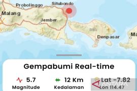
Padangpanjang Meteorology, Climatology and Geophysics Agency (BMKG) spokesman Furqan said the epicenter of the temblor was located between 1.5 degrees southern latitude and 101.06 degrees eastern longitude at a depth of 10 kilometers under the sea level, 5 kilometers southeast of Muara Labuh.
"Luckily the magnitude of the earthquake was not strong enough and felt only by the people in Solok Selatan," Furqan said, adding that the BMKG was still uncertain if the temblor was triggered by Mount Talang.
At 00.55 am Western Indonesia Standard Time (WIB) on Tuesday another earthquake measuring 5.0 on the Richter scale also hit northwest of Saumlaki in the eastern Indonesian province of Maluku.
The quake was centered 426 km southeast of the provincial capital Ambon at a depth of 201 km beneath sea level, the Meteorology, Climatology and Geophysics Agency (BMKG) said in its official website.
The temblor was not strong enough to trigger a tsunami, it said.
Tuesday`s quake was the latest in a series of quakes that hit Saumlaki. An earthquake measuring 5.2 on the Richter scale rocked the area on May 22.
Indonesia sits on the Pacific "Ring of Fire" where the meeting of continental plates causes high volcanic and seismic activity.
Maluku province lies at a meeting point of the country`s two main chains of volcanoes.
(O001/A/H-NG/a/o001)
(ANTARA)
Editor: Ella Syafputri
Copyright © ANTARA 2011


