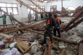
The temblor did not have a potential to trigger a tsunami but forced local residents to rush out of the houses in panic.
The quake`s epicenter was located at 2.88 degrees southern latitude and 100.97 degrees eastern longitude, around 37 km southwest of Mukomuko, Bengkulu, and at a depth of 28 km below sea level, according to the Meteorological, Geophysics and Climatology Agency (BMKG).
Bengkulu had been at least hit by two major earthquakes respectively in 2000 at the magnitude of 7.3 on The Richter Scale and in 2007 at 7.9 on the Richter Scale.
The powerful earthquakes devastated thousands of houses and killed hundreds of people.
Indonesia, a vast archipelago of 237 million people, is prone to earthquakes and volcanos because it sits along the Pacific "Ring of Fire", a horseshoe-shaped string of faults that lines the Pacific Ocean.
At least three earthquakes shook Indonesia on Thursday morning (August 4).
Earlier at 5.52 am Western Indonesian Standard Time (WIB) on Thursday, an earthquake measuring 5.3 on the Richter scale jolted Bitung, North Sulawesi Province.
The temblor`s epicenter was situated at 0.14 degrees southern latitude and 125.35 degrees eastern longitude, around 177 km southeast of Bitung, and at a depth of 10 km below sea level.
At 3.02 am WIB on the same day, a magnitude-5.5 earthquake hit Padangsidempuan, North Sumatra.
The tremor was located at 0.93 degrees northern latitude and - 98.67 degrees eastern longitude, about 83 km southwest of Padangsidempuan, and at a depth of 29 Km below sea level.
Last Tuesday (August 2), an earthquake measuring 5.4 on the Richter scale jolted Saumlaki, the capital of Maluku Tenggara Barat District, Maluku Province.
(SYS/F001)
Editor: Suryanto
Copyright © ANTARA 2011


