#satellite image data
Collection of satellite image data news, found 11 news.
Indonesia's capacity to respond to natural disasters faces significant obstacles due to limitations in current ...
The National Research and Innovation Agency (BRIN) uses remote sensing technology to calculate the danger of faults as ...
The National Research and Innovation Agency (BRIN) supports the use of microalgae as a food source for Indonesia ...
The National Research and Innovation Agency (BRIN) stated that maximizing the use of swampland is a crucial step to ...
Indonesia should develop a space exploration-based economic sector in the future, head of the National Research and ...
The National Research and Innovation Agency (BRIN) managed image data obtained from remote sensing satellite for ...
The National Research and Innovation Agency (BRIN) is striving to strengthen and attain self-reliance in obtaining ...
No less than six hotspots, suggestive of forest fires, were found in North Penajam Paser District, East Kalimantan, the ...
The LAPAN satellite image data indicated the presence of 935 hotspots suggestive of forest fires in West Kalimantan on ...
President Joko Widodo (Jokowi) embarked on a working visit to West Kalimantan Province on Thursday in accordance with ...
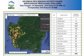
The LAPAN satellite image data showed 949 hotspots were spotted in West Kalimantan on Sept 3-4, 2019, a notable ...


