The quakes epicenter was located at 8.87 degree southern latitude and at 110.57 degree eastern longitude, at a depth of 10 kilometers, and some 93 kilometers southwest of Gunung Kidul District, according to information from Yogyakarta meteorological office.
The tremor was felt for four seconds by residents of Bantul, Yogyakarta City, Kulon Progo, Sleman, Gunung Kidul, Wonogiri, Trenggalek, Ponorogo and Pacitan.
The quakes intensity was Modified Mercalli Intensity (MMI) III, which is considered mild.
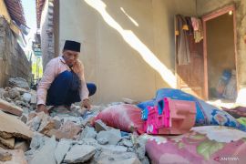
On Wednesday night, six houses in Jember district, East Java, were damaged after a 6.2-magnitude earthquake hit the southern part of the province.
"The earthquake, which was centered 127 kilometers southeast of Malang district, was strongly felt in Jember district and caused major and minor damages to six houses in several sub-districts," head of the emergency and logistics section at the Jember district disaster mitigation board (BPBD) Heru Widagdo said here on Thursday.
Most of the houses damaged due to the earthquake were located in the districts southern coastal sub-districts of Puger, Gumukmas and Mayang, he said.
Two houses were seriously damaged in Puger sub-district; three houses in Gumukmas sub-district, with total material losses of Rp20 million; and one house with material loss of Rp5 million, he said.
He made it clear that the BPBD has continued to gather data on the number of victims.
The earthquake was located 9.32 degrees southern latitude and 113.12 degrees eastern longitude at a depth of 69 kilometers, and did not have the potential to cause a tsunami, the Meteorology, Climatology and Geophysics Agency (MKG) said earlier.
The earthquake was categorized as a strong one. The impact of the earthquake was felt by people in Malang, Yogyakarta, Lumajang and Jember, according to the agencys map.(*)
Editor: Heru Purwanto
Copyright © ANTARA 2016

