The magmatic eruptions produced thick ash rising to heights of between two thousand and 3,400 meters from the volcano`s peak.Jakarta (ANTARA News) - After rumbling since August 2017, the 3,142-meter-high Mount Agung has finally erupted, forcing a temporary closure of the I Gusti Ngurah Rai International Airport located on the world`s most famous resort island of Bali.
The Indonesian Volcanology and Geological Disaster Mitigation Center (PVMBG) has raised the alert level of Mount Agung from three to four, indicating eruption hazards on and near the volcano.
The alert level was raised, as the eruptions of Mount Agung have shifted from phreatic to magmatic since a red glow was visible from the peak of Mount Agung on Nov 26 at 9 p.m. local time, according to I Gede Suantika, the mitigation head of PVMBG.
The magmatic eruptions produced thick ash rising to heights of between two thousand and 3,400 meters from the volcano`s peak.
Suantika has forecast that larger explosions might occur as is indicated by the continuous ash puffs that are sometimes accompanied by explosive eruptions along with a weak sound of boom audible in the radius of up to 12 kilometers from the mountain`s peak.
The danger zone has been expanded from six kilometers to eight kilometers from the volcano`s peak.
People living within a 10-kilometer radius towards the north, northeast, southeast, south, and southwest of the mount have been advised to evacuate.
Villages located within the danger zone are Ban, Dukuh, Baturinggit, Sukadana, Kubu, Tulamben, Datah, Nawakerti, Pitpit, Bhuana Giri, Bebandem, Jungutan, North Duda, Amerta Bhuana, Sebudi, Besakih, and Pempatan.
The danger zone can be changed at any time based on the condition of the volcano.
No casualties have been reported so far, and 40 thousand people have left the area, though tens of thousands still need to move, according to Sutopo Purwo Nugroho, spokesman of the National Disaster Mitigation Agency.
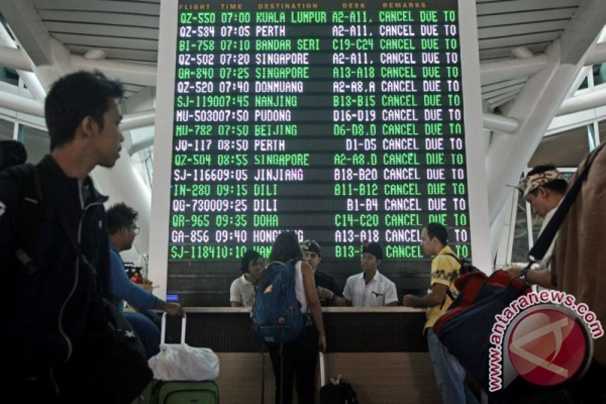
Volcanic ash dispersed into the air over the airport after the second eruption forced its closure for 24 hours from 7 a.m. local time on Nov 27.
The Indonesian Transportation Ministry has issued a notice to airman no. A-4242/17 on the closure.
A total of 57 international flights and 39 domestic flights were canceled from Saturday until Sunday at 11:59 p.m. local time.
State-owned airport operator PT Angkasa Pura I has confirmed that a total of 445 flights were canceled following the 24-hour closure of the I Gusti Ngurah Rai International Airport, which is located some 60 kilometers from the volcano.
Some 59 thousand passengers were affected by the flight cancellations, Arie Ahsanurrohim, spokesman of PT Angkara Pura I office at the I Gusti Ngurah Rai International Airport, said.
The canceled flights comprise 97 international arrivals, 99 international departures, 124 domestic arrivals, and 125 domestic departures.
The airport operator has prepared alternative airports to serve flights to Bali.
The alternative airports include the Juanda Airport in Surabaya, East Java Province; Lombok Praya Airport in West Nusa Tenggara; Sultan Hasanussin Airport in Makassar, South Sulawesi; Sultan Aji Muhammad Sulaiman Sepinggan in Balikpapan, East Kalimantan; Adi Soemarmo Airport in Solo, Central Java; Ahmad Yani Airport in Semarang, Central Java; and Adi Sutjipto in Yogyakarta, Central Java.
The authorities have provided buses for transporting the stranded passengers to the Gilimanuk and Padang Bai seaports, among other locations, if they are keen on traveling to alternative airports by land.
PT Angkasa Pura I has arranged ticket refund services, flight rescheduling services, a foreign consulate general counter, as well as Balinese traditional music and dance performances to entertain the stranded passengers.
The Bali airport authorities have arranged services, including alternative means of transportation, for passengers whose flights were cancelled owing to the closure of I Gusti Ngurah Rai International Airport following the eruption of Mount Agung.
Some four thousand meal boxes have been provided for international passengers and two thousand others for domestic passengers who have been stranded.
Meanwhile, Bali Governor Made Mangku Pastika has urged the public to stay calm and follow procedures outlined by the Bali disaster mitigation office in the wake of magmatic eruptions of Mount Agung in Karangasem District.
"I hope all residents of Bali, particularly Karangasem, would remain calm and vigilant, as Mount Agung erupts," the governor stated here, Sunday evening.
He also urged people living in the danger zone to follow the government`s instructions, particularly those concerning evacuation.
To prevent casualties, residents of villages located in the danger zone should stay at the evacuation locations, he noted.
Records since 1800 reveal that Mount Agung had experienced four mega eruptions, respectively in 1908, 1823, 1843, and 1963. The 1963 eruption killed some one thousand people.
On Oct 29, 2017, the Indonesian authorities lowered the alert level of Mount Agung located in Karangasem district, Bali Island, from Level 4 to Level 3 and allowed thousands of Balinese evacuees to return home after living more than a month in evacuation centers.
As for the island`s tourism, earlier the local tourist office had ensured that despite Mount Agung showing increased activity, 98 percent of the tourist attractions on Bali Island remain safe for visit.
"According to information from the BNPB, 98 percent of the tourist areas remain safe in Bali, even if Mount Agung erupts," Dewa Gede Ngurah Byomantara, head of the Board`s Bali Tourism Hospitality Division 3, was quoted as saying on the official website of the Indonesian Foreign Ministry in October 2017.
If the volcano were to erupt, only two percent of Bali`s tourist attractions -- Besakih, Tulamben, and Tirta Gangga -- would be affected.
"Kuta, Ubud, Nusa Dua, and Sanur are located far from Mount Agung. Until now, we believe that the areas beyond 12 kilometers from Mount Agung`s crater remain safe," he added.
(T.F001/A/KR-BSR/F001)
Reporter: Fardah Assegaf
Editor: Heru Purwanto
Copyright © ANTARA 2017


