The hotspots were monitored by the Terra, Aqua, NPP Suomi satellites, Zakaria Ahmad, the Data and Information Section head of the Banda Aceh BMKG Station, stated on Monday
"Based on the satellite data, most hotspots are in Southeast Aceh and Gayo Lues, with a confidence level of 63-82 percent," he remarked.
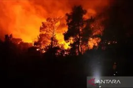
The 24 hotspots had emerged since Sunday (Feb 9), as the weather in Aceh was quite hot and sunny.
The temperature in regions, such as Gayo Lues, Southeast Aceh, Aceh Besar, Bener Meriah, Subulussalam, Central Aceh, Aceh Tamiang, and Aceh Jaya, had reached up to 33 degrees Celsius, with low-intensity rainfall.
"Hence, we urge the local people to not set fire to clear land for farming, as it could lead to forest fires and trigger haze in Aceh," Ahmad stated.
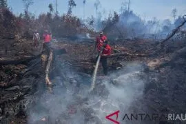
According to a report from the Aceh Disaster Management Office (BPBA) on Monday, wildfire burned a half-hectare land in Mon Ikeun Lhoknga, Aceh Besar District.
The fire allegedly arose from the unsupervised burning of trash, so the fire expanded rapidly and spread around the area, as the weather was hot at the time.
"In addition to Aceh Besar, wildfires also occurred in Southeast Aceh, Aceh Jaya, and peatland areas in South Aceh. However, the fires have already been extinguished," Sunawardi, Aceh BPBA chief executive, stated.
Related news: Two hotspots detected in Aceh EDITED BY INE
Translator: Khalis Surry, Fardah
Editor: Suharto
Copyright © ANTARA 2020