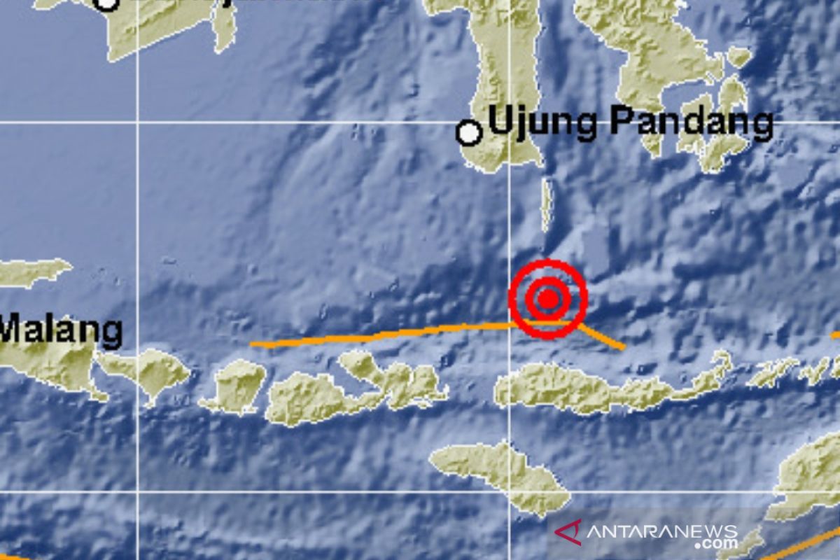
The tremblor was felt by those residing in areas near the epicenter and in Denpasar, Bali Island, Head of the Earthquake and Tsunami Center at the Jakarta-based Meteorology, Climatology, and Geophysics Agency (BMKG) Rahmat Triyono reported.
The moderate-intensity quake, epicentered some 130 kilometers away from south of Kota Benteng in Kepulauan Selayar District, South Sulawesi Province, at a depth of 599 kilometers, did not trigger a tsunami, he remarked.
Taking into account the location and depth of its epicenter, Triyono believes the earthquake might have been induced by subduction.
No aftershocks or damages and casualties following the first quake were reported as of 7 a.m. local time.
Located on the Circum-Pacific Belt, also called the Ring of Fire, the meeting points of several tectonic plates where frequent volcanic and seismic activities occur, Indonesia is susceptible to natural disasters, including earthquakes and volcanic eruptions.
Indonesia's earthquake zones spread from the islands of Sumatra, Java, Bali, Lombok, Flores, and Alor to the Banda Sea as well as the islands of Seram, Sulawesi, Maluku, and Papua.
Early this week, multiple earthquakes, measuring over 5.0 on the Richter scale, also jolted several areas in Indonesia.
The Jakarta-based Meteorology, Climatology, and Geophysics Agency (BMKG) reported that the first 5.2-magnitude earthquake rattled Yogyakarta at 2:50 a.m. local time.
The second earthquake, of magnitude 5.5, shook southwest of Banda Aceh, the capital of Aceh Province, at about 7:58 a.m. local time, while the third quake jolted northwest of Maluku Tenggara Barat District in Maluku Province at around 9:08 a.m. local time.
In 2018, the BMKG recorded that Indonesia had borne the impact of 11,577 earthquakes, including several ones causing major casualties, with the figure notably increasing from that in 2017.
The BMKG data indicated that 11,577 earthquakes, with varying magnitudes and depths, hit in 2018, while merely 7,172 earthquakes were recorded in 2017.
Hence, it indicates that Indonesia had borne witness to a significant rise in the number of tectonic earthquakes in 2018.
Several earthquake-related events that hit Indonesia in 2018, including the liquefaction in Palu, a tsunami that struck prior to the issuance of a tsunami warning in Palu, and the Sunda Strait Tsunami, had occurred for the first time.
In 2004, Indonesia had also borne the brunt of a major catastrophe that claimed hundred thousand lives in Banda Aceh and impacted several other parts of Aceh Province after the areas were rattled by a deadly tsunami following a powerful earthquake.
Related news: Series of quakes of over 5.0-magnitude hit Indonesia on Monday
Related news: Four earthquakes of varying magnitudes jolt Indonesia on Tuesday
EDITED BY INE
Translator: Desi P, Rahmad Nasution
Editor: Fardah Assegaf
Copyright © ANTARA 2020
