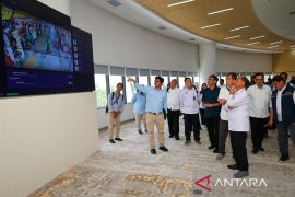
Frankly, these figures (the area of the capital area) are changing because they are monitored and controlled in practice. Now, the area of the Central Government Main Area is about 6,670 hectares. This area is a private forest area that has become aJakarta (ANTARA) - On the afternoon of February 17, the House's Commission IV meeting room in Jakarta was bursting with noises produced by council members that clashed with the voice of Environment and Forestry Minister, Siti Nurbaya Bakar.
It was not a rare occurrence. Such a sight was common during meetings of Commission IV of the House of Representatives with officials at the Environment and Forestry Ministry, especially if there were debates revolving around some issues.
Four topics were discussed that day, but the issue of an over 3.3 million-hectare (ha) palm oil plantation in a forest area triggered the heated argument during the meeting. To add to the chaos was the discussion on the development planning for the new Capital City in East Kalimantan.
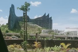
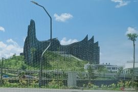
Nagara Rimba Nusa became the design concept of Nusantara City, which means government (Nagara), forest (Rimba), and island (Nusa). In the initial design issued by Urban+ creative studio, the winner of the new capital city design contest, the area took up only around two to three thousand ha and is a small part of the entire National Capital Expansion Area (KPIKN) that reaches about 202 thousand ha.
In the initial planning, the government stated that the main governmental area was estimated to reach 5,600 ha. However, during a meeting with the commission that day, Minister Bakar stated that in accordance with Law (UU) Number 3 of 2022 on the Capital City, the total area of the capital's marine waters reached 68,189 ha and the land area reached 256,142 ha, comprising the expansion area of approximately 199,962 ha and the National Capital Region covering an area of 56,180 ha.
Related news: Jokowi to appoint authority head and deputy head of Nusantara city
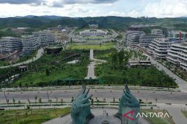
Nagara Rimba Nusa, which is the Central Government Main Area (KIPP) of the Nusantara Capital City, is planned to be constructed on an area of 6,671 ha, which is part of the State Capital Region. Appendix II of the Capital City Law stipulated the main area's size.
"Frankly, these figures (the area of the capital area) are changing because they are monitored and controlled in practice. Now, the area of the Central Government Main Area is about 6,670 hectares. This area is a private forest area that has become a production forest again," Bakar remarked.
The first stage of the capital city land's share from forest areas has been completed, whereas an area of 41,492 ha of the production forest area was an addendum to the industrial plantation forest, which was the work area of PT ITCI Hutani Manunggal, that had changed its function into a convertible production forest, according to the Decree on the Change of the Production Forest's Function to Convertible Production Forest (SK.109/2020 dated February 18, 2020).
The second stage of the city's land provision from forest areas, which is the share of convertible production forest into Other Land Use Areas (APL) would await a proceeding from the Capital City's Authority.
The main governmental area in Sepaku Sub-district, North Penajam Paser District, East Kalimantan is located on the south side of the capital city. Apart from the convertible production forest, Pemaluan, Bumi Harapan, and Bukit Raya are the three villages that intersect with the area that will become the core of the government center.
Related news: Capital city relocation to help achieve economic equality: ministry
Green spaces at the capital city
The choice of "Nagara Rimba Raya" as a title is not without reason. The winner of the design competition was keen to define a city that remains forest-friendly in order to restore Kalimantan as the lungs of the world.
On Wednesday, February 2, while visiting the Red and White House, National Development Planning Minister, Suharso Monoarfa, stressed that the entire area of 256,142 ha would not be used for government buildings, as most of it will be left as forest. The ratio would be 20-percent buildings and 80-percent forests.
Bakar deemed the decision to be in line with President Joko Widodo's directives. Nusantara City was built on the basis of the Naraga Rimba Nusa design concept, which lead to the decision of leaving 80 to 90 percent of its area as forest. She reiterated this aspect at least twice during the meeting.
Data from the Environment and Forestry Ministry showed that the composition of forest and land areas in the capital city and its extended areas comprised one percent of limited production forest (HPT), 16 percent of convertible production forest, 17 percent of production forest, 25 percent of conservation forest and 41 percent of land for other uses. Thus, the forest area is indeed wider there, reaching 59 percent.
With such percentage, many were concerned that the capital city's development would eat away the forest areas in Kalimantan. A member of Commission IV of the House of Representatives from the Gerindra Party faction, Endro Hermono, urged the ministry to properly observe and implement the recommendations listed in the Strategic Environmental Study, including taking precautionary measures against the impact of development and population growth on the remaining forests.
He also implored the ministry to conduct a study to identify environmental and forestry problems in the buffer zone in preparation for the capital's establishment.
Related news: Indonesia's new capital and the future of Jakarta
A member of Commission IV of the House of Representatives from the National Awakening Party faction, Daniel Johan, suggested the ministry to conduct a disaster and mitigation study, considering that Nusantara City's landscape was in the form of forested valleys where endemic animals and plants are found. It aimed to serve as a measure to avoid committing another disaster, while transfer of the capital city itself was a way to escape Jakarta's yearly flooding problem.
He pressed for a transparent environmental and forestry study. Should it turn out to be dangerous, it would not bode well to get caught up in the ambitious desire to move the capital city and end up brushing off the environmental impact analysis.
Based on the ministry's data, only 42.31 percent, or 108,362.91 ha of the Nusantara City area are in the form of forests, mangroves, and swamp forests (peat). The rest were plantations, reaching 29.18 percent; shrubs, 11.65 percent; mixed crops, 7.36 percent; waters, 3.13 percent; empty land, 2.09 percent; fields, 1.61 percent; transportation, 0.94 percent; and other uses, mining, 0.88 percent; buildings or public facilities, 0.37 percent; rice fields, 0.34 percent; grassland, 0.07 percent; sand or sea sand dunes, 0.03 percent; land sand or dunes, 0.02 percent; as well as cemented surface or field, 0.01 percent.
Related news: New capital city reflects RI's commitment to global warming: KSP
A struggle for conducting reforestation
In the Master Plan for the Nusantara Capital, which is an attachment to the State Capital Law, the capital's development was based on values, such as smart, green, beautiful, and sustainable. It further explained that the new state capital was built on the basis of the concept of a forest city. At least 50 percent of the city would be greenery to ensure environmental resilience.
The principle of being in harmony with nature is one of the main performance indicators in the development of the Nusantara Capital. The first of such indicators was more than 75 percent of the 256,142 ha of area being for green spaces, of which 65 percent was protected area and 10 percent was for food production.
Second, 100 percent of the population can access recreational green spaces within 10 minutes. Third, 100-percent replacement of green space for every high rise institutional, commercial, and residential building, or buildings with more than four floors.
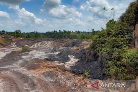
The current condition of the New Capital Extended Area was in the spotlight. The ex-mining pits, which are easy to find there, have drawn the attention of members of Commission IV of the House of Representatives from the Prosperous Justice faction, Andi Akmal Pasluddin, and Muslim from the Democrat Party faction.
Pasluddin reminded the government to not use the State Revenue and Expenditure Budget to rehabilitate the mining pits though ensure that the companies operating there will pay for it.
Meanwhile, Muslim reminded that land acquisition for the extended area should not be a detriment to the community. Nusantara City must be integrated with the people living nearby.
Related news: New capital development: Phase 1 to focus on basic infrastructure
Bakar denied allegations of massive forest conversion to build Nusantara City. Moreover, President Joko Widodo has emphasized that the forest area should not be less than 80 percent.
Forest and land rehabilitation had been expedited, and cutting and planting techniques per lane were conducted by immediately cultivating endemic plants. Modern nurseries, with a capacity of 15 million tree seedlings per year, are deemed crucial that provide various types of woody trees originating from the local area.
The Capital City development plan was readied based on recommendations from the results of the ministry's strategic environmental rapid assessment in 2019 and was further assessed by the National Development Planning Ministry in 2020. Bakar noted that strategic environmental assessment for spatial planning details was also available.
The development of Nagara Rimba Nusa was in progress. As with the council, public participation is certainly expected through public consultation, deliberation, partnerships, conveying aspirations, or other involvement in accordance with the law and regulations.
Related news: Ministry optimistic of climate villages to share innovations
Related news: Waste management can reduce greenhouse emissions: deputy minister
Translator: Virna P S, Mecca Yumna
Editor: Fardah Assegaf
Copyright © ANTARA 2022
