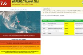
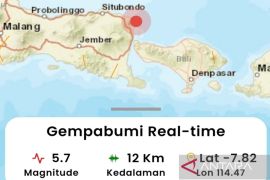
The epicenter of the first earthquake was located at 7.65 degrees south latitude and 122.43 degrees east longitude, 11 kilometers under the Flores Sea, BMKG's coordinator for earthquake and tsunami mitigation, Daryono, informed here on Saturday.
Meanwhile, the second earthquake was centered at 7.57 degrees south latitude and 122.45 degrees east longitude, 12 km under the sea.
The distance between the epicenters of the first and second earthquakes was relatively close at about 4.2 km, he noted.
The two earthquakes were categorized as shallow, he said adding, they did not trigger tsunamis.
"Interestingly, these two earthquakes have different source mechanisms. The first earthquake had a strike-slip mechanism, but the second one has a thrust fault mechanism," Daryono informed.
Related news: 230 homes damaged in Flores Sea quake: BNPB
Furthermore, since the two earthquakes occurred due to different mechanisms and were almost 1.5 hours apart, he said he suspected that the second earthquake happened because of the static triggering effect of the first earthquake.
"However, looking at the epicenter, these two earthquakes are not located in the path of the Flores Back-Arc Thrusting earthquake source, but rather to the north from the widely-known source," he added.
As of 3:58 p.m. local time, the results of BMKG’s monitoring showed one aftershock activity, with the largest magnitude of 4.0 recorded at 3:19 p.m.
On December 14, 2021, an earthquake with a magnitude of 7.4, had been recorded in the Flores Sea.
Related news: 5,511 families affected by Flores Sea quake: Selayar BPBD
Translator: Devi R, Kenzu T
Editor: Suharto
Copyright © ANTARA 2022
