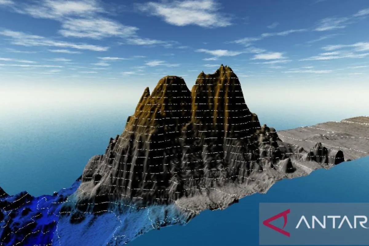
This newly discovered underwater mountain is about 260 kilometers south of Pacitan district, precisely on the border between Central Java province and East Java province.Bogor, W Java (ANTARA) - A survey team from the Marine and Coastal Area Mapping Center (PKLP) of the Geospatial Information Agency (BIG) has discovered a seamount or an underwater mountain in the southern waters of Pacitan district, East Java province.
According to a statement received on Monday, the mountain’s base is located on the seafloor at a depth of about six thousand meters. It measures about 2,200 meters in height.
"This newly discovered underwater mountain is about 260 kilometers south of Pacitan district, precisely on the border between Central Java province and East Java province," coordinator for marine area mapping at BIG, Fajar Triady Mugiarto, informed.
He said that BIG carried out a technical coordination meeting with a number of parties, namely geologists, and hydrographers, as well as representatives of the Pacitan district government and the East Java provincial government regarding the discovery of the seamount.
The meeting was also attended by representatives from the Energy and Mineral Resources Ministry, the National Research and Innovation Agency (BRIN), and the Indonesian Navy's Hydro-Oceanographic Center (Pushidrosal).
Currently, the Pacitan district government is finalizing a proposal for naming the new underwater mountain.
"Hopefully, the name of this volcano will later be included in the Indonesian gazetteer (a geographical index or directory containing the names and locations of geographical objects) Gazeter RI,” the BIG official said.
It is planned that the name of the newly discovered underwater mountain will be submitted to the General Bathymetric Chart of the Oceans (GEBCO) Sub-Committee on Undersea Feature Names (SCUFN), he added.
The GEBCO is under the auspices of the International Hydrographic Organization (IHO) and the Intergovernmental Oceanographic Commission (IOC) of the United Nations Educational, Scientific, and Cultural Organization (UNESCO).
The discovery of the seamount was the result of a joint survey conducted by the PKLP of BIG and BRIN in the southern regions of Java, Bali, and Nusa Tenggara in September–November 2022.
The activity, which was carried out using BRIN’s survey vessel Baruna Jaya III and lasted 52 days, aimed to obtain detailed underwater topography data called bathymetry. The data will be used in calculating the claim for the extended continental shelf zone.
Related news: Geospatial agency records 17 thousand islands in Indonesia
Related news: Gov't compiles 90% of thematic geospatial information'
Translator: Linna Susanti, Uyu Liman
Editor: Tia Mutiasari
Copyright © ANTARA 2023