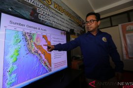
Ambon Meteorology and Geophysics Agency spokesman Benny Sipolo said here on Wednesday the epicenter of the earthquake was located at 6.66 degrees southern latitude and 132,42 degrees eastern longitude, and 188 kilometers southwest of Tual at a depth of 10 kilometers.
After attending a coordination meeting with Tual city and Southeast Maluku district government officials, Sipolo said the temblor did not have the potential of triggering tsunami.
Indonesia`s 17,000 islands are scattered along a belt of volcanic and seismic activity, known as the Pacific "Ring of Fire", making the country one of the most quake prone places on earth.
Sipolo said his agency was intensively monitoring seismic developments in Southeast Maluku, especially in the cities of Tual and Saumlaki as the region was prone to earthquakes.
Minor temblors of less than 3 on the Richter scale happen there almost every day.
Maluku province is prone to earthquakes and tsunami as it is
situated at the confluence of three major tectonic plates, namely the Pacific, Indo Australia, and Eurasia.
The Indo Australia plate comes under Eurasia and meets with the Pacific plate, resulting in an irregular fracture.
Quake prone areas in Maluku are Ambon island, part of Southeast Mauku district, Seram and Buru islands, but so far Maluku has never experienced a powerful earthquake followed by a massive tsunami.
(Uu.O001/HAJM)
Editor: Priyambodo RH
Copyright © ANTARA 2011


