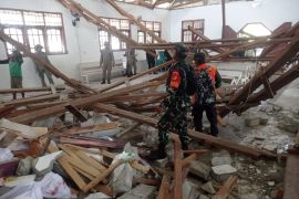
Ambon Meteorology, Climatology and Geophysics Agency spokesman Benny Sipolo said the epicenter of the temblor was located at 4.09 degrees southern latitude and 130.76 degrees eastern longitude at a depth of 10 kilometers below sea level, or some 48 kilometers northeast of Bula town.
But he said there was no information, so far, about casualties or material damage from the earthquake.
Located at the meeting point of three major plates of the Pacific, Indo Australia, and Eurasia, Maluku Province is prone to earthquakes and tsunamis.
Earlier on Sunday, February 5, 2012, Aru Islands District in the province was also jolted by an earthquake measuring 5.5 on the Richter scale, though it did not trigger a tsunami.
Benny Sipolo said Sunday`s earthquake was located at 4.45 degrees southern latitude and 133.90 degrees eastern longitude at a depth of 10 km beneath the sea, and about 1,059 kilometers northwest of Dobo, capital of Aru Island district.
More than 17,000 Indonesian islands are scattered along a belt of volcanic and seismic activity, known as the Pacific "Ring of Fire", and the islands are one of the most quake-prone areas on earth.
(O001/INE/f001)
Editor: Ella Syafputri
Copyright © ANTARA 2012


