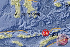
Local Meteorology, Climatology and Geophysics Agency (BMKG) spokesman Sumawan said the epicenter of the earthquake was located between 10.01 degrees Southern Latitude and 120.84 degrees Eastern Longitude at a depth of 10 kilometers.
The Indonesian archipelago suffers frequent earthquakes, lying in an area of intense seismic activity where several tectonic plates collide.
Earlier on Tuesday morning, an earthquake measuring 5.0 on the Richter scale shook Sarmi district in Papua province at 4.33 am local time.
Papua BMKG reported that the epicenter of the earthquake was located between 2.64 degrees Southern Latitude and 139.55 degrees Eastern Longitude at a depth of 13 km, or some 43 km southeast of Sarmi.
But there was no immediate report of casualty or material damage resulted from the earthquake.
(Uu.O001/KR-BSR/F001)
Editor: Priyambodo RH
Copyright © ANTARA 2016
