All stakeholders must seek the best solution without blaming each other or justifying the problem.Pontianak, W Kalimantan (ANTARA) - After remaining flooded for one month, Sintang, the capital city of Sintang district in West Kalimantan, on Sunday (November 21, 2021) started to show signs of people's activities again.
The main road in the city, the Melawi highway, which was heavily inundated, can now be navigated even though it is located along the riverbank, with the water level still reaching an average adult's waist.
The flood, said to be the largest in the last 50 years, has created several short- and long-term works, including ascertaining the reason for the floods and taking preventive measures so the disaster does not happen again.
The flooding occurred in the Kapuas drainage basin in West Kalimantan, especially in the concave part of the winding river, director general of drainage basin and protected forest control at the Ministry of Environment and Forestry, Helmi Basalamah, said.
The affected area is on the river border, which is a back swamp, he added.
The flood-affected area witnessed heavy rain intensity from the end of October until early November, he said. The accumulated intensity was recorded at 294 mm, resulting in flood discharge of 15,877.12 cu m per secs, which exceeded the river capacity of 12,279.80 cu m per secs, leading to an overflow of discharge at 3,597.32 cu m per secs, he informed.
The upstream part of the water catchment area (DTA) was dominated by very steep hillsides, he noted. The locations of flooding were meanders and river concaves in the downstream part of the drainage basin, he said. They were also lowlands with a system of floodplains, he added.
Related news: BNI offers food assistance to Sintang flood victims
Meeting point
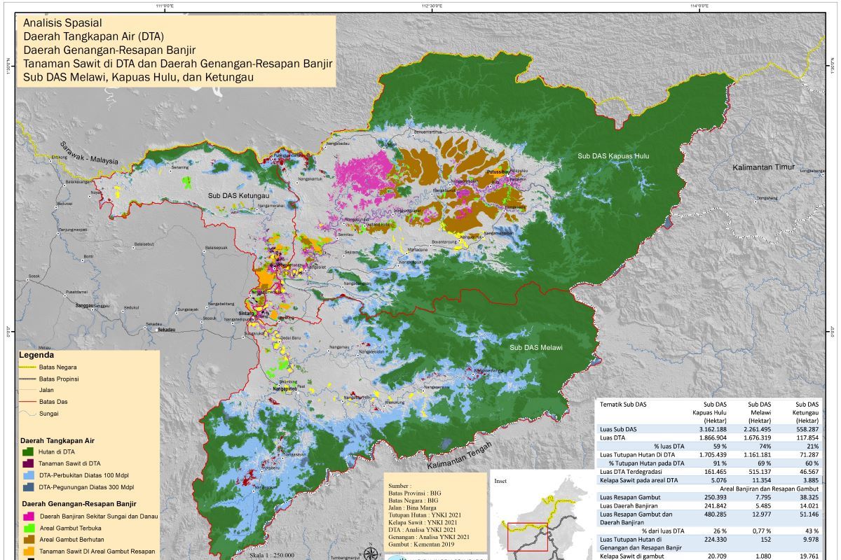
Director of the Indonesian Natural Capital Foundation (YNKI), Haryono, said Sintang district is geographically the meeting point of three sub-drainage basins in West Kalimantan: Kapuas, Melawi, and Ketungau.
The three sub-drainage basins have a very wide coverage area, he said. From the Kapuas Hulu district, the Kapuas basin stretches over 3.162 million hectares, he informed.
Melawi in Melawi district is spread over 2.262 million hectares, while Ketungau in the north of Sintang city covers 558 thousand hectares, he added.
"With a very wide area coverage, it can be imagined if these three subs change in terms of function, then the Sintang district, especially in Sintang city, will feel the impact, like what happened last month," Haryono said.
YNKI has conducted a mapping for these sub-drainage basins' conditions, he informed. Then, the Kapuas' catchment area is 59 percent of its 1.866-million-hectare area, he said. Melawi encompasses 74 percent or 1.676 million hectares, he added. Meanwhile, Ketungau covers 21 percent or 117 thousand hectares, Haryono said.
The forest coverage in Kapuas DTA is 1.709 million hectares (91 percent of Sub Kapuas DTA), Sub Melawi at 1.161 million hectares (74 percent), and Sub Ketungau 71,287 hectares (60 percent), he added.
Meanwhile, the width of degraded DTA in the Sub Kapuas drainage basin reached 161,465 hectares, Sub Melawi 515,137 hectares, and Sub Ketungau 46,567 hectares, he said.
In the DTA area, there are 5,076 hectares of palm oil plants in Sub Kapuas, 11,354 hectares in Sub Melawi, and 3,885 hectares in Sub Ketungau, he added.
Peat catchment and flooded areas in each sub-basins are 26 percent at Kapuas, 0.77 percent at Melawi, and 43 percent at Ketungau, he said. The percentage of forest area in the Kapuas catchment area is around 89.6 percent, 2 percent in Melawi, and 26 percent in Ketungau, he added.
"The figure does not include the mine area and illegal gold mining at the Kapuas basin that reaches 7,939 hectares, 7,688 hectares at Melawi, and 1,539 hectares at Ketungau," Haryono said.
Related news: Ministry to rehabilitate Kalimantan's watersheds
Rain intensity
The central mountainous area of Kalimantan is an area with the most extreme rain levels on the island, Haryono informed.
Thus, Sub Kapuas, Melawi, and Ketungau fall into the category of wet, or their rainfall is above 200 mm per month, he said. Moreover, the dry season only happens for two months in the area, he added.
Even some zones in the Sub Kapuas fall into the category of very high rainfall of above 400 mm per month in a two-month period, he informed.
"If rain falls in the Sub Kapuas, there is a 480-thousand-hectare catchment area that is still very wide and all around," Haryono said. The case is different in Melawi and Ketungau, where rainfall will go directly downstream of the river, he added.
That is because, in Melawi, the area of flooding catchment is only 0.77 percent, he disclosed.
"What is more, the catchment area of the hills that is above one hundred meters from sea level has been mostly degraded," he explained.
The large water cubication, geographical conditions, and the 20-meter difference in altitude between the coast and Sintang district have made the flood slow to recede, he said.
He estimated that for every one hundred kilometers of the Kapuas River, the difference in water level is only four meters.
Related news: BNPB urges regional govt to fulfill needs of Sintang flood victims
Short- and long-term revitalization
With those conditions, efforts that must be done to mitigate disasters include preparing integrated steps for the short- and long-term, Haryono said.
Rehabilitation and revitalization of the flood catchment and peat areas are necessary, especially as these are used by palm oil plantations and unlicensed gold mining, he added.
In addition to rehabilitating catchment areas, including those used for palm oil plantations, a change of capital city needs to be considered, he said. It is because of the condition of the small flooding catchment area, he added.
"It is not enough to maximize the potentials of small lakes near Sintang city. It will be inadequate to hold the water discharge if similar conditions happen again," Haryono explained.
Regarding the suggestion of dredging the Kapuas river estuary, Haryono reminded that the Kapuas river starts at Kapuas Hulu and ends at four zones, which are Jungkat at Mempawah district, Kakap river at Kubu Raya district, Teluk Pakedai at Kubu Raya district, and finally Kubu in the same district.
The river flow starts to divide in Sukalanting, Kubu Raya district, before finally ending at the four estuaries, he said.
He assessed that the river estuary at Jungkat is too small so it is not effective to accelerate river flow.
"But how to fix those three sub-drainage basins (remains a question)," he said.
Regarding the warning from the Meteorology, Climatology, and Geophysical Agency (BMKG) about the prevalence of La Nina until February 2022, Haryono said nothing can be done to prevent flooding given the complex and widespread problems and the short time to plan for solutions.
However, local governments must prepare for mitigation in the event of a similar disaster, he said. The mitigation includes preparing evacuation sites, securing access and essential services, as well as providing food assistance during disasters, he added.
"In addition, all stakeholders must seek the best solution without blaming each other or justifying the problem," he said.
It is in accordance with Law No. 23 of 2014 on local government, he noted. The law states that the implementation of drainage basin management across districts/cities in one province is the authority of the provincial government, he said. The permits for palm oil plantations are also issued by district heads and governors, he added.
That is why commitment and consistency from policymakers is required to tackle the flooding disaster in Sintang, he said.
Related news: Floods submerge over one thousand homes in Sintang, West Kalimantan
Related news: President sends 5,000 aid packages for flood victims in W Kalimantan
Editor: Suharto
Copyright © ANTARA 2021
