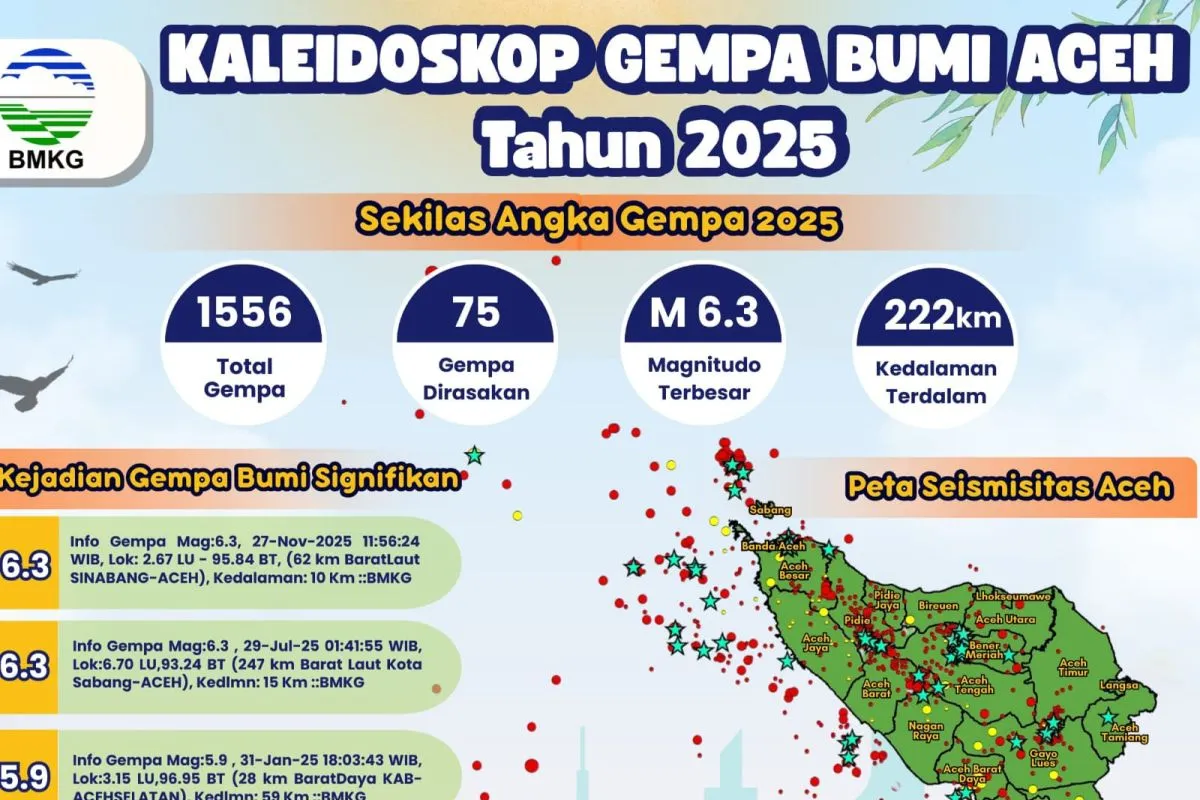
“Throughout 2025, the ground in Aceh continued to move, with 1,556 earthquakes recorded,” said Head of the BMKG Aceh Besar Geophysics Station, Andi Azhar Rusdin, on Thursday.
Of the total number of earthquakes, seventy-five were felt by residents. The strongest quake reached a magnitude of 6.3, while the deepest hypocenter was recorded at 222 kilometers.
Based on hypocenter depth, most earthquakes in Aceh during 2025 were classified as shallow. BMKG recorded 1,466 earthquakes at depths of less than 60 kilometers.
Meanwhile, ninety events were categorized as intermediate earthquakes, occurring at depths greater than 60 kilometers and up to less than 300 kilometers.
No earthquakes exceeding a depth of 300 kilometers were recorded in Aceh during the year. “The number of earthquakes in 2025 increased by 39 percent compared to the previous year,” Andi said.
He added that five earthquakes were considered significant during the year. Two of them registered a magnitude of 6.3, namely the earthquake in Sinabang, Simeulue District, on November 27, 2025, at a depth of 10 kilometers, and another in Sabang on July 29, 2025, at a depth of 15 kilometers.
“Meanwhile, three earthquakes with a magnitude of 5.9 were recorded. The first occurred on January 31 in South Aceh District at a depth of 59 kilometers. The second took place on April 8 in Sinabang at a depth of 30 kilometers, and the last occurred in Blangpidie, Southwest Aceh District, on May 11 at a depth of 83 kilometers,” Andi said.
In terms of timing, the highest number of earthquakes occurred in September 2025, with 239 events, six of which were felt by residents. October recorded 218 earthquakes with six felt, November saw 146 earthquakes with six felt, while December recorded 104 earthquakes, seventeen of which were felt.
“October recorded 218 earthquakes with six felt, November had 146 with six felt, and December saw 104 earthquakes, but seventeen of them were felt,” he said.
Andi emphasized that the data serve as a reminder that Aceh lies in an active seismic zone, underscoring the importance of collective preparedness.
He encouraged the public to use earthquake information as a means to enhance vigilance rather than fuel anxiety.
“Remain alert, prepare an emergency bag, know evacuation routes and assembly points, and monitor official information from BMKG. Preparedness today means safety in the future,” Andi Azhar Rusdin said.
Indonesia is located along the Pacific Ring of Fire, a zone where three major tectonic plates, Eurasian, Indo-Australian, and Pacific, converge. This position makes the country, including Aceh, highly prone to earthquakes and tsunamis, while also giving it high volcanic activity with more than 130 active volcanoes.
Related news: Disaster relief must be transparent, without vested interests: Prabowo
Related news: Prabowo inspects structure, facilities of Danantara housing in Aceh
Related news: Baznas aids over 116,000 flood and landslide victims across Sumatra
Translator: Rahmat Fajri, Primayanti
Editor: Azis Kurmala
Copyright © ANTARA 2026


