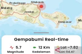
The quake`s epicenter was located at 7.57 degrees southern latitude, and 106.64 degrees eastern longitude, at a depth of 35 Km below sea level, around 78 km southwest of Sukabumi, the National Meteorological, Climatology and Geophysics Agency said on its website here on Monday.
A number of local people rushed out of their houses in panic when the temblor occurred.
"I immediately rushed out of my home when I felt strong tremor. I accompanied by child who was about to sleep when the earthquake shook for around two seconds," Leli, a housewife, said.
Reports on damage or casualties were not available immediately.
"We are still waiting for a report from disaster mitigation officers in the region, and so far there is no report on damage. However, we are still on alert for possible aftershocks," Ferry A Furqon, the head of the Sukabumi Disaster Mitigation Office, said.
Indonesia sits on the Pacific "Ring of Fire" where the meeting of continental plates causes high volcanic and seismic activity.
Last July 24, an earthquake measuring 5.5 on the Richter scale jolted Sukabumi District, West Java Province, and its surroundings at 3.23 pm local time.
The quake`s epicenter was located at 7.52 degrees southern latitude, and 106.43 degrees eastern longitude, around 86 km southwest of Sukabumi, and at a depth of 30 km below sea level, according to information from the national Meteorological, Climatology, and Geophysical Agency (BMKG) on Sunday.
The temblor did not have the potential to trigger a tsunami, the BMKG said. (*)
HAJM/F001/O001
Editor: Jafar M Sidik
Copyright © ANTARA 2011
