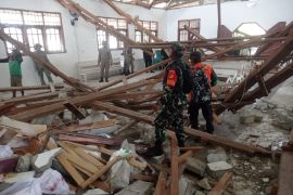
The quake's epicenter was located at 4.27 degrees northern latitude and 127.83 degrees eastern longitude, some 131 kilometers (km) northeast of Melonguane, North Sulawesi, and at a depth of 23 km, the Meteorology, Climatology and Geophysics Agency (BMKG) stated here on Friday.
The agency had earlier recorded an aftershock of magnitude 5.2 from the7.2-magnitude earthquake that was later updated to 6.7, off the west coast of West Nias District, North Sumatra Province, on Friday.
The epicenter of the aftershock was located at the coordinates of 0.21 degrees northern latitude and 96.58 degrees eastern longitude, and at a depth of 10 km.
The shallow earthquake had a normal fault mechanism.
Until Friday at 14:30 WIB, the BMKG had detected three aftershocks after the West Nias earthquake.
The Nias earthquake was felt at modified Mercalli intensity scale (MMI) III- IV in Gunung Sitoli, Nias, West Nias, and South Nias; MMI III in Banda Aceh; and MMI II in Central Aceh.
Related news: Magnitude-7.2 quake rattles West Nias, North Sumatra
Related news: A 5.7-earthquake rattles North Maluku's West Halmahera
Related news: 5.3-magnitude earthquake rocks Banda Aceh on Friday night
Translator: Martha HS, Fardah
Editor: Sri Haryati
Copyright © ANTARA 2021


