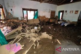
"BNPB is involved in preparing a risk map for IKN in the next 20–25 years," head of the Disaster Data, Information, and Communication Center of the BNPB, Abdul Muhari, said on Friday.
According to him, the risk map has been reflected in infrastructure development plans, including for controlling river flows, building drainage, and water catchment areas.
The use of the risk map is crucial given IKN's lowland topography, which is crossed by the Sepaku River that is prone to overflowing and causing flooding during heavy rains, Muhari added.
His party has also made several efforts to control the risk of flooding from the North Penajam Paser area, which intersects with IKN, with the help of central/regional governments and related authorities from the private sector.
Efforts involving optimizing water absorption and normalizing river flow in North Penajam Paser have yielded promising results.
Related news: BNPB highlights several flood-impacted areas based on forecast map
For example, the flooding caused by Sepaku River in Karang Jinawi village, Suka Raja, Bukit Raya on June 16, 2024, was quickly resolved with no impact on IKN. The local community could also immediately return to their activities, according to Muhari.
In addition, BNPB and the Meteorology, Climatology, and Geophysics Agency (BMKG) carried out weather modification operations some time ago by sowing 16 tons of salt to control rain in IKN.
"All forms of disaster risks have been included in the study, which supports the smooth running of accelerated development activities at IKN for the present and in the future," Muhari informed.
Controlling hydro-meteorological disasters and tackling the high potential for rain in Kalimantan has become the government's focus, especially amid plans to hold the first Independence Day ceremony at IKN on August 17.
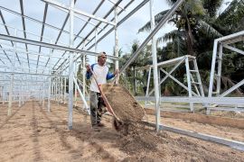
Currently, the ceremonial field and the State Palace projects, which are being built under operational cooperation by PT PP and PT Wijaya Karya, have reached 77.9 percent completion, higher than the previous target of 73 percent.
The facilities that have been built so far include the grand guest plaza area, ceremony field, lobby area, and 34-pillar column area.
Related news: Indonesia SAR prepares map of Jakarta`s flood-prone areas
Translator: M. Riezko Bima E, Resinta Sulistiyandari
Editor: Yuni Arisandy Sinaga
Copyright © ANTARA 2024
