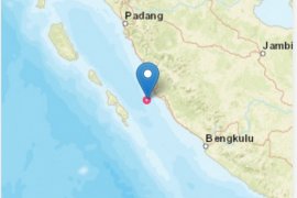
The epicenter of the quake which struck at 11.58 a.m. was located at 3.33 degrees southern latitude and 101 degrees eastern longitude at a depth of 26 km, head of the District Natural Disaster Mitigation Board (BPBD) Jasni Bahari said quoting a report from the Meteorology, Climatology and Geophysics Agency (BMKG).
He said the temblor forced local people to stay outdoors but they had got back to their homes now.
The condition had returned to normal following the quake and local people resumed their activities as usual, he said.
There was no immediate report of casualties or material damage.
Bengkulu is one of the areas in Indonesia prone to quakes. Indonesia sits on the Pacific "Ring of Fire" where the meeting of continental plates causes high volcanic and seismic activity.
The province was hit by a powerful quake with a magnitude of 7.9 in 2007, leaving tens of people dead and destroying thousands of houses with material losses estimated at hundreds of billions of rupiahs.
Earlier, a 7.3 magnitude quake also rattled the province in 2000 in which tens of people perished.
(Uu.S012/H-NG/S012)
Editor: Priyambodo RH
Copyright © ANTARA 2011


